You are here: Home > Network List > TA - USArray Transportable Network (new EarthScope stations) Stations List
> Station 121A Cookes Peak, Deming, NM, USA > Earthquake Result Viewer
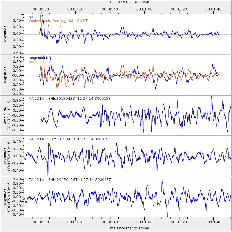
121A Cookes Peak, Deming, NM, USA - Earthquake Result Viewer
*The percent match for this event was below the threshold and hence no stack was calculated.
| Earthquake location: |
Near Coast Of Ecuador |
| Earthquake latitude/longitude: |
-2.1/-79.7 |
| Earthquake time(UTC): |
2015/04/28 (118) 11:19:50 GMT |
| Earthquake Depth: |
85 km |
| Earthquake Magnitude: |
5.4 MW, 5.3 mb |
| Earthquake Catalog/Contributor: |
ISC/ISC |
|
| Network: |
TA USArray Transportable Network (new EarthScope stations) |
| Station: |
121A Cookes Peak, Deming, NM, USA |
| Lat/Lon: |
32.53 N/107.79 W |
| Elevation: |
1652 m |
|
| Distance: |
43.5 deg |
| Az: |
324.768 deg |
| Baz: |
136.963 deg |
| Ray Param: |
$rayparam |
*The percent match for this event was below the threshold and hence was not used in the summary stack. |
|
| Radial Match: |
49.514893 % |
| Radial Bump: |
400 |
| Transverse Match: |
61.915604 % |
| Transverse Bump: |
400 |
| SOD ConfigId: |
7422571 |
| Insert Time: |
2019-04-18 13:42:16.341 +0000 |
| GWidth: |
2.5 |
| Max Bumps: |
400 |
| Tol: |
0.001 |
|
Signal To Noise
| Channel | StoN | STA | LTA |
| TA:121A: :BHZ:20150428T11:27:14.800015Z | 2.8616714 | 1.9614E-7 | 6.854036E-8 |
| TA:121A: :BHN:20150428T11:27:14.800015Z | 0.4408555 | 5.1236935E-8 | 1.1622161E-7 |
| TA:121A: :BHE:20150428T11:27:14.800015Z | 0.8041455 | 6.707888E-8 | 8.3416346E-8 |
| Arrivals |
| Ps | |
| PpPs | |
| PsPs/PpSs | |


