You are here: Home > Network List > AK - Alaska Regional Network Stations List
> Station GAMB Gambell Broadband > Earthquake Result Viewer
GAMB Gambell Broadband - Earthquake Result Viewer

| Earthquake location: |
Solomon Islands |
| Earthquake latitude/longitude: |
-9.5/156.4 |
| Earthquake time(UTC): |
2014/09/25 (268) 09:13:50 GMT |
| Earthquake Depth: |
10 km |
| Earthquake Magnitude: |
6.0 MB |
| Earthquake Catalog/Contributor: |
NEIC PDE/NEIC COMCAT |
|
| Network: |
AK Alaska Regional Network |
| Station: |
GAMB Gambell Broadband |
| Lat/Lon: |
63.78 N/171.70 W |
| Elevation: |
10 m |
|
| Distance: |
77.0 deg |
| Az: |
13.947 deg |
| Baz: |
212.359 deg |
| Ray Param: |
0.050636582 |
| Estimated Moho Depth: |
26.5 km |
| Estimated Crust Vp/Vs: |
1.86 |
| Assumed Crust Vp: |
6.24 km/s |
| Estimated Crust Vs: |
3.35 km/s |
| Estimated Crust Poisson's Ratio: |
0.30 |
|
| Radial Match: |
89.65066 % |
| Radial Bump: |
400 |
| Transverse Match: |
66.906975 % |
| Transverse Bump: |
400 |
| SOD ConfigId: |
796777 |
| Insert Time: |
2014-10-09 09:19:10.472 +0000 |
| GWidth: |
2.5 |
| Max Bumps: |
400 |
| Tol: |
0.001 |
|
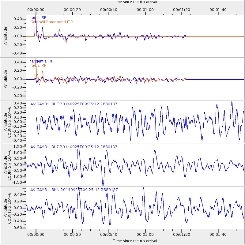
Signal To Noise
| Channel | StoN | STA | LTA |
| AK:GAMB: :BHZ:20140925T09:25:12.288013Z | 2.892316 | 3.1278088E-7 | 1.0814201E-7 |
| AK:GAMB: :BHN:20140925T09:25:12.288013Z | 1.2310897 | 1.058859E-7 | 8.60099E-8 |
| AK:GAMB: :BHE:20140925T09:25:12.288013Z | 1.057825 | 1.2641375E-7 | 1.1950347E-7 |
| Arrivals |
| Ps | 3.8 SECOND |
| PpPs | 12 SECOND |
| PsPs/PpSs | 16 SECOND |


