You are here: Home > Network List > AK - Alaska Regional Network Stations List
> Station WAT2 Susitna Watana 2, AK, USA > Earthquake Result Viewer
WAT2 Susitna Watana 2, AK, USA - Earthquake Result Viewer
| Earthquake location: |
Solomon Islands |
| Earthquake latitude/longitude: |
-9.5/156.4 |
| Earthquake time(UTC): |
2014/09/25 (268) 09:13:50 GMT |
| Earthquake Depth: |
10 km |
| Earthquake Magnitude: |
6.0 MB |
| Earthquake Catalog/Contributor: |
NEIC PDE/NEIC COMCAT |
|
| Network: |
AK Alaska Regional Network |
| Station: |
WAT2 Susitna Watana 2, AK, USA |
| Lat/Lon: |
62.96 N/148.59 W |
| Elevation: |
1366 m |
|
| Distance: |
83.5 deg |
| Az: |
22.14 deg |
| Baz: |
234.444 deg |
| Ray Param: |
0.04613138 |
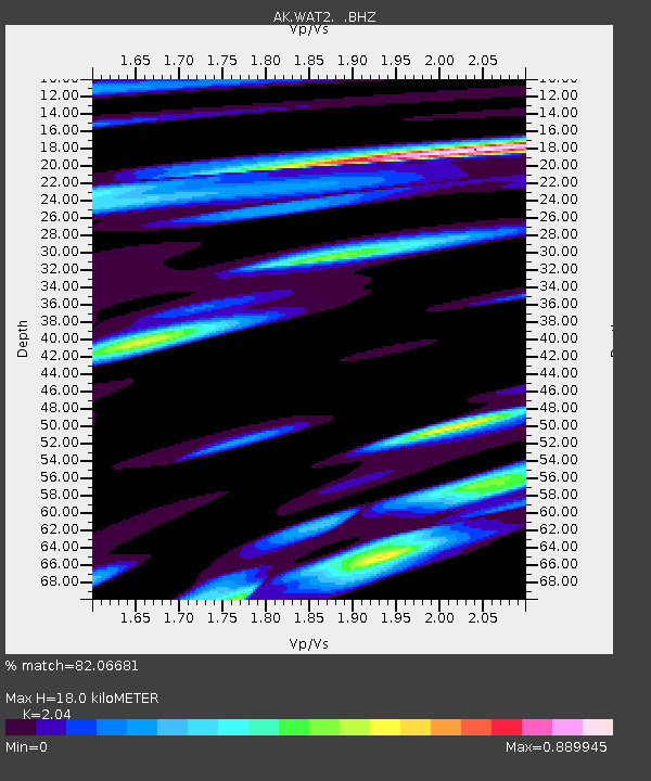
| Estimated Moho Depth: |
18.0 km |
| Estimated Crust Vp/Vs: |
2.04 |
| Assumed Crust Vp: |
6.566 km/s |
| Estimated Crust Vs: |
3.219 km/s |
| Estimated Crust Poisson's Ratio: |
0.34 |
|
| Radial Match: |
82.06681 % |
| Radial Bump: |
400 |
| Transverse Match: |
66.271324 % |
| Transverse Bump: |
400 |
| SOD ConfigId: |
796777 |
| Insert Time: |
2014-10-09 09:20:46.457 +0000 |
| GWidth: |
2.5 |
| Max Bumps: |
400 |
| Tol: |
0.001 |
|

Signal To Noise
| Channel | StoN | STA | LTA |
| AK:WAT2: :BHZ:20140925T09:25:47.447986Z | 4.606066 | 3.1576124E-7 | 6.855334E-8 |
| AK:WAT2: :BHN:20140925T09:25:47.447986Z | 1.3330777 | 2.1386103E-7 | 1.6042654E-7 |
| AK:WAT2: :BHE:20140925T09:25:47.447986Z | 1.3426646 | 1.422456E-7 | 1.0594276E-7 |
| Arrivals |
| Ps | 2.9 SECOND |
| PpPs | 8.1 SECOND |
| PsPs/PpSs | 11 SECOND |


