You are here: Home > Network List > AK - Alaska Regional Network Stations List
> Station WAT4 Susitna Watana 4, AK, USA > Earthquake Result Viewer
WAT4 Susitna Watana 4, AK, USA - Earthquake Result Viewer
| Earthquake location: |
Solomon Islands |
| Earthquake latitude/longitude: |
-9.5/156.4 |
| Earthquake time(UTC): |
2014/09/25 (268) 09:13:50 GMT |
| Earthquake Depth: |
10 km |
| Earthquake Magnitude: |
6.0 MB |
| Earthquake Catalog/Contributor: |
NEIC PDE/NEIC COMCAT |
|
| Network: |
AK Alaska Regional Network |
| Station: |
WAT4 Susitna Watana 4, AK, USA |
| Lat/Lon: |
62.83 N/147.94 W |
| Elevation: |
1191 m |
|
| Distance: |
83.7 deg |
| Az: |
22.416 deg |
| Baz: |
235.047 deg |
| Ray Param: |
0.046012674 |
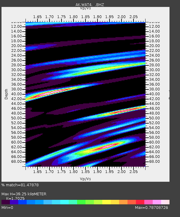
| Estimated Moho Depth: |
39.25 km |
| Estimated Crust Vp/Vs: |
1.70 |
| Assumed Crust Vp: |
6.566 km/s |
| Estimated Crust Vs: |
3.857 km/s |
| Estimated Crust Poisson's Ratio: |
0.24 |
|
| Radial Match: |
81.47878 % |
| Radial Bump: |
400 |
| Transverse Match: |
52.929592 % |
| Transverse Bump: |
400 |
| SOD ConfigId: |
796777 |
| Insert Time: |
2014-10-09 09:20:52.898 +0000 |
| GWidth: |
2.5 |
| Max Bumps: |
400 |
| Tol: |
0.001 |
|

Signal To Noise
| Channel | StoN | STA | LTA |
| AK:WAT4: :BHZ:20140925T09:25:48.307971Z | 3.1965516 | 2.2406654E-7 | 7.0096334E-8 |
| AK:WAT4: :BHN:20140925T09:25:48.307971Z | 0.7209973 | 8.0369176E-8 | 1.1146946E-7 |
| AK:WAT4: :BHE:20140925T09:25:48.307971Z | 1.5759156 | 8.5652296E-8 | 5.4350814E-8 |
| Arrivals |
| Ps | 4.3 SECOND |
| PpPs | 16 SECOND |
| PsPs/PpSs | 20 SECOND |


