You are here: Home > Network List > AK - Alaska Regional Network Stations List
> Station WAT5 Susitna Watana 5, AK, USA > Earthquake Result Viewer
WAT5 Susitna Watana 5, AK, USA - Earthquake Result Viewer
| Earthquake location: |
Solomon Islands |
| Earthquake latitude/longitude: |
-9.5/156.4 |
| Earthquake time(UTC): |
2014/09/25 (268) 09:13:50 GMT |
| Earthquake Depth: |
10 km |
| Earthquake Magnitude: |
6.0 MB |
| Earthquake Catalog/Contributor: |
NEIC PDE/NEIC COMCAT |
|
| Network: |
AK Alaska Regional Network |
| Station: |
WAT5 Susitna Watana 5, AK, USA |
| Lat/Lon: |
63.06 N/148.23 W |
| Elevation: |
1691 m |
|
| Distance: |
83.7 deg |
| Az: |
22.153 deg |
| Baz: |
234.763 deg |
| Ray Param: |
0.04599547 |
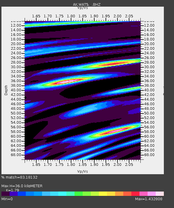
| Estimated Moho Depth: |
36.0 km |
| Estimated Crust Vp/Vs: |
1.79 |
| Assumed Crust Vp: |
6.566 km/s |
| Estimated Crust Vs: |
3.668 km/s |
| Estimated Crust Poisson's Ratio: |
0.27 |
|
| Radial Match: |
83.18132 % |
| Radial Bump: |
400 |
| Transverse Match: |
62.49278 % |
| Transverse Bump: |
400 |
| SOD ConfigId: |
796777 |
| Insert Time: |
2014-10-09 09:20:53.335 +0000 |
| GWidth: |
2.5 |
| Max Bumps: |
400 |
| Tol: |
0.001 |
|

Signal To Noise
| Channel | StoN | STA | LTA |
| AK:WAT5: :BHZ:20140925T09:25:48.428027Z | 2.277154 | 2.9298351E-7 | 1.2866215E-7 |
| AK:WAT5: :BHN:20140925T09:25:48.428027Z | 0.5891427 | 7.173868E-8 | 1.2176793E-7 |
| AK:WAT5: :BHE:20140925T09:25:48.428027Z | 2.200868 | 1.9199578E-7 | 8.7236394E-8 |
| Arrivals |
| Ps | 4.4 SECOND |
| PpPs | 15 SECOND |
| PsPs/PpSs | 19 SECOND |


