You are here: Home > Network List > CB - China National Seismic Network Stations List
> Station GZH Guangzhou,Guangdong Province > Earthquake Result Viewer
GZH Guangzhou,Guangdong Province - Earthquake Result Viewer
| Earthquake location: |
Fiji Islands Region |
| Earthquake latitude/longitude: |
-20.9/-178.7 |
| Earthquake time(UTC): |
2015/04/28 (118) 16:39:38 GMT |
| Earthquake Depth: |
579 km |
| Earthquake Magnitude: |
6.2 MWB |
| Earthquake Catalog/Contributor: |
NEIC PDE/NEIC COMCAT |
|
| Network: |
CB China National Seismic Network |
| Station: |
GZH Guangzhou,Guangdong Province |
| Lat/Lon: |
23.65 N/113.65 E |
| Elevation: |
65 m |
|
| Distance: |
79.4 deg |
| Az: |
300.339 deg |
| Baz: |
118.368 deg |
| Ray Param: |
0.04719486 |
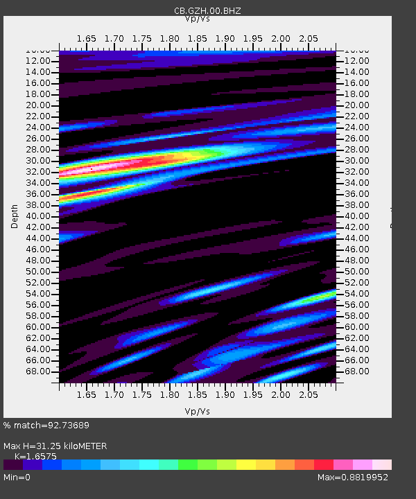
| Estimated Moho Depth: |
31.25 km |
| Estimated Crust Vp/Vs: |
1.66 |
| Assumed Crust Vp: |
6.276 km/s |
| Estimated Crust Vs: |
3.786 km/s |
| Estimated Crust Poisson's Ratio: |
0.21 |
|
| Radial Match: |
92.73689 % |
| Radial Bump: |
308 |
| Transverse Match: |
79.22851 % |
| Transverse Bump: |
392 |
| SOD ConfigId: |
7422571 |
| Insert Time: |
2019-04-18 13:52:05.543 +0000 |
| GWidth: |
2.5 |
| Max Bumps: |
400 |
| Tol: |
0.001 |
|

Signal To Noise
| Channel | StoN | STA | LTA |
| CB:GZH:00:BHZ:20150428T16:50:14.899976Z | 42.389328 | 2.992977E-6 | 7.060685E-8 |
| CB:GZH:00:BHN:20150428T16:50:14.899976Z | 7.8827844 | 4.757175E-7 | 6.034892E-8 |
| CB:GZH:00:BHE:20150428T16:50:14.899976Z | 14.364877 | 1.0018052E-6 | 6.973991E-8 |
| Arrivals |
| Ps | 3.4 SECOND |
| PpPs | 13 SECOND |
| PsPs/PpSs | 16 SECOND |


