You are here: Home > Network List > CI - Caltech Regional Seismic Network Stations List
> Station LRL Laurel Mtn Radio Fac, Ridgecrest, CA, USA > Earthquake Result Viewer
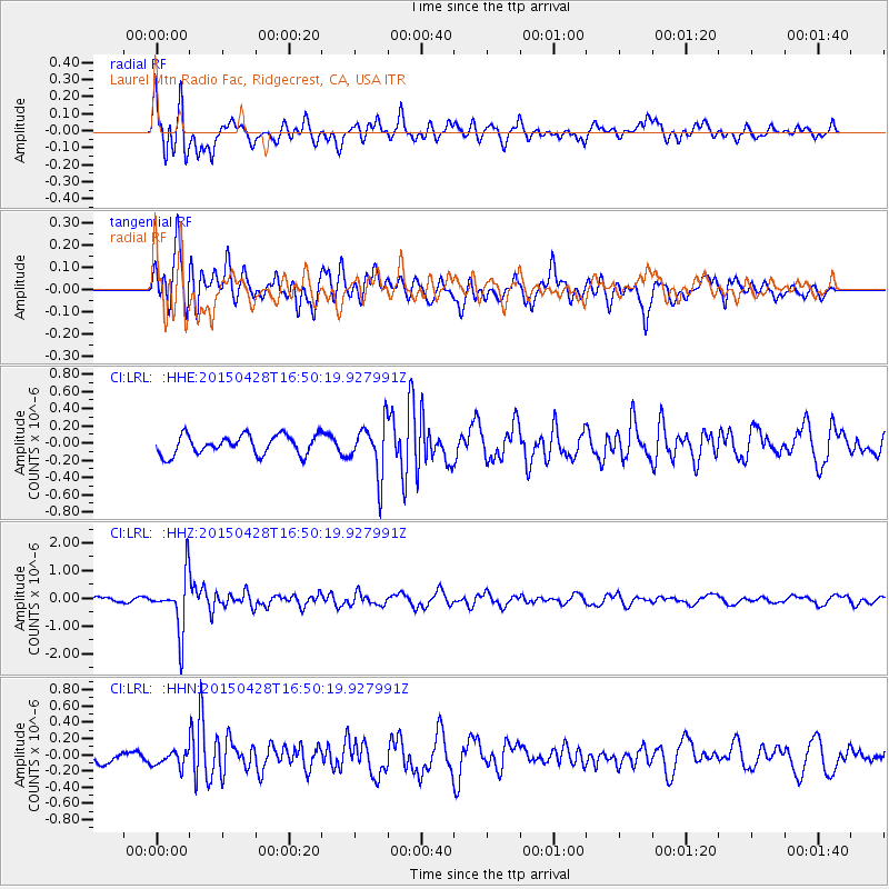
LRL Laurel Mtn Radio Fac, Ridgecrest, CA, USA - Earthquake Result Viewer
*The percent match for this event was below the threshold and hence no stack was calculated.
| Earthquake location: |
Fiji Islands Region |
| Earthquake latitude/longitude: |
-20.9/-178.7 |
| Earthquake time(UTC): |
2015/04/28 (118) 16:39:38 GMT |
| Earthquake Depth: |
579 km |
| Earthquake Magnitude: |
6.2 MWB |
| Earthquake Catalog/Contributor: |
NEIC PDE/NEIC COMCAT |
|
| Network: |
CI Caltech Regional Seismic Network |
| Station: |
LRL Laurel Mtn Radio Fac, Ridgecrest, CA, USA |
| Lat/Lon: |
35.48 N/117.68 W |
| Elevation: |
1340 m |
|
| Distance: |
80.5 deg |
| Az: |
46.351 deg |
| Baz: |
235.981 deg |
| Ray Param: |
$rayparam |
*The percent match for this event was below the threshold and hence was not used in the summary stack. |
|
| Radial Match: |
73.7654 % |
| Radial Bump: |
400 |
| Transverse Match: |
83.5297 % |
| Transverse Bump: |
400 |
| SOD ConfigId: |
7422571 |
| Insert Time: |
2019-04-18 13:52:48.337 +0000 |
| GWidth: |
2.5 |
| Max Bumps: |
400 |
| Tol: |
0.001 |
|
Signal To Noise
| Channel | StoN | STA | LTA |
| CI:LRL: :HHZ:20150428T16:50:19.927991Z | 6.94243 | 1.0038914E-6 | 1.4460231E-7 |
| CI:LRL: :HHN:20150428T16:50:19.927991Z | 1.2277542 | 9.3433904E-8 | 7.610147E-8 |
| CI:LRL: :HHE:20150428T16:50:19.927991Z | 2.6783895 | 3.0425147E-7 | 1.1359493E-7 |
| Arrivals |
| Ps | |
| PpPs | |
| PsPs/PpSs | |


