You are here: Home > Network List > TA - USArray Transportable Network (new EarthScope stations) Stations List
> Station D04E Lakebay, WA, USA > Earthquake Result Viewer
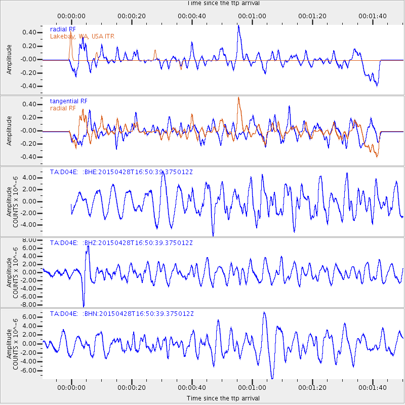
D04E Lakebay, WA, USA - Earthquake Result Viewer
*The percent match for this event was below the threshold and hence no stack was calculated.
| Earthquake location: |
Fiji Islands Region |
| Earthquake latitude/longitude: |
-20.9/-178.7 |
| Earthquake time(UTC): |
2015/04/28 (118) 16:39:38 GMT |
| Earthquake Depth: |
579 km |
| Earthquake Magnitude: |
6.2 MWB |
| Earthquake Catalog/Contributor: |
NEIC PDE/NEIC COMCAT |
|
| Network: |
TA USArray Transportable Network (new EarthScope stations) |
| Station: |
D04E Lakebay, WA, USA |
| Lat/Lon: |
47.18 N/122.77 W |
| Elevation: |
45 m |
|
| Distance: |
84.4 deg |
| Az: |
34.577 deg |
| Baz: |
231.057 deg |
| Ray Param: |
$rayparam |
*The percent match for this event was below the threshold and hence was not used in the summary stack. |
|
| Radial Match: |
43.143574 % |
| Radial Bump: |
400 |
| Transverse Match: |
43.021023 % |
| Transverse Bump: |
400 |
| SOD ConfigId: |
7422571 |
| Insert Time: |
2019-04-18 13:55:29.568 +0000 |
| GWidth: |
2.5 |
| Max Bumps: |
400 |
| Tol: |
0.001 |
|
Signal To Noise
| Channel | StoN | STA | LTA |
| TA:D04E: :BHZ:20150428T16:50:39.375012Z | 2.88353 | 2.7609167E-6 | 9.57478E-7 |
| TA:D04E: :BHN:20150428T16:50:39.375012Z | 0.8902807 | 1.5553074E-6 | 1.7469855E-6 |
| TA:D04E: :BHE:20150428T16:50:39.375012Z | 2.0532055 | 3.1455793E-6 | 1.5320335E-6 |
| Arrivals |
| Ps | |
| PpPs | |
| PsPs/PpSs | |


