You are here: Home > Network List > TA - USArray Transportable Network (new EarthScope stations) Stations List
> Station I23K Minto, Yukon-Koyukuk, AK, USA > Earthquake Result Viewer
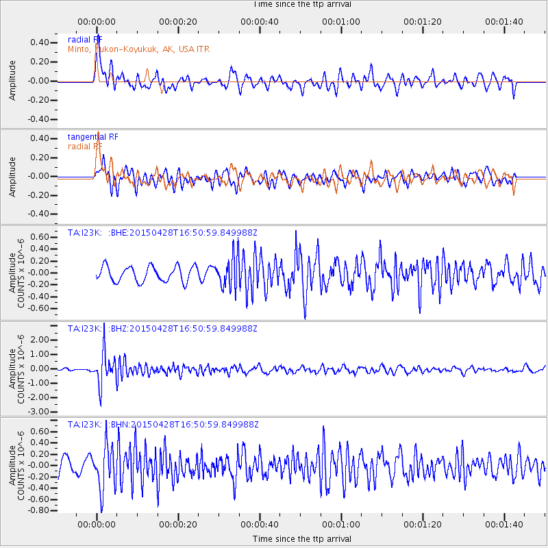
I23K Minto, Yukon-Koyukuk, AK, USA - Earthquake Result Viewer
*The percent match for this event was below the threshold and hence no stack was calculated.
| Earthquake location: |
Fiji Islands Region |
| Earthquake latitude/longitude: |
-20.9/-178.7 |
| Earthquake time(UTC): |
2015/04/28 (118) 16:39:38 GMT |
| Earthquake Depth: |
579 km |
| Earthquake Magnitude: |
6.2 MWB |
| Earthquake Catalog/Contributor: |
NEIC PDE/NEIC COMCAT |
|
| Network: |
TA USArray Transportable Network (new EarthScope stations) |
| Station: |
I23K Minto, Yukon-Koyukuk, AK, USA |
| Lat/Lon: |
65.15 N/149.36 W |
| Elevation: |
149 m |
|
| Distance: |
88.7 deg |
| Az: |
11.937 deg |
| Baz: |
207.231 deg |
| Ray Param: |
$rayparam |
*The percent match for this event was below the threshold and hence was not used in the summary stack. |
|
| Radial Match: |
72.742096 % |
| Radial Bump: |
400 |
| Transverse Match: |
64.59552 % |
| Transverse Bump: |
400 |
| SOD ConfigId: |
7422571 |
| Insert Time: |
2019-04-18 13:55:41.415 +0000 |
| GWidth: |
2.5 |
| Max Bumps: |
400 |
| Tol: |
0.001 |
|
Signal To Noise
| Channel | StoN | STA | LTA |
| TA:I23K: :BHZ:20150428T16:50:59.849988Z | 9.044015 | 1.0879406E-6 | 1.2029399E-7 |
| TA:I23K: :BHN:20150428T16:50:59.849988Z | 2.3824172 | 3.8908337E-7 | 1.6331454E-7 |
| TA:I23K: :BHE:20150428T16:50:59.849988Z | 2.0612314 | 2.6521505E-7 | 1.2866826E-7 |
| Arrivals |
| Ps | |
| PpPs | |
| PsPs/PpSs | |


