You are here: Home > Network List > TA - USArray Transportable Network (new EarthScope stations) Stations List
> Station J04D Umpqua National Forest, Toketee, OR, USA > Earthquake Result Viewer
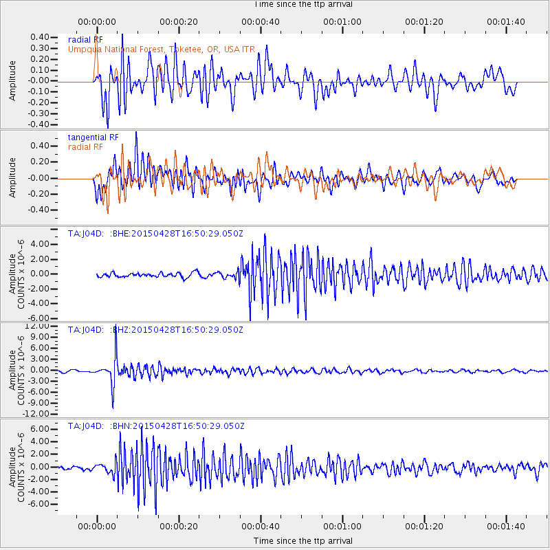
J04D Umpqua National Forest, Toketee, OR, USA - Earthquake Result Viewer
*The percent match for this event was below the threshold and hence no stack was calculated.
| Earthquake location: |
Fiji Islands Region |
| Earthquake latitude/longitude: |
-20.9/-178.7 |
| Earthquake time(UTC): |
2015/04/28 (118) 16:39:38 GMT |
| Earthquake Depth: |
579 km |
| Earthquake Magnitude: |
6.2 MWB |
| Earthquake Catalog/Contributor: |
NEIC PDE/NEIC COMCAT |
|
| Network: |
TA USArray Transportable Network (new EarthScope stations) |
| Station: |
J04D Umpqua National Forest, Toketee, OR, USA |
| Lat/Lon: |
43.24 N/122.11 W |
| Elevation: |
1948 m |
|
| Distance: |
82.3 deg |
| Az: |
37.973 deg |
| Baz: |
231.92 deg |
| Ray Param: |
$rayparam |
*The percent match for this event was below the threshold and hence was not used in the summary stack. |
|
| Radial Match: |
79.6805 % |
| Radial Bump: |
400 |
| Transverse Match: |
81.1113 % |
| Transverse Bump: |
400 |
| SOD ConfigId: |
7422571 |
| Insert Time: |
2019-04-18 13:55:42.186 +0000 |
| GWidth: |
2.5 |
| Max Bumps: |
400 |
| Tol: |
0.001 |
|
Signal To Noise
| Channel | StoN | STA | LTA |
| TA:J04D: :BHZ:20150428T16:50:29.050Z | 15.030459 | 3.897452E-6 | 2.5930362E-7 |
| TA:J04D: :BHN:20150428T16:50:29.050Z | 3.4727628 | 8.2575804E-7 | 2.3778128E-7 |
| TA:J04D: :BHE:20150428T16:50:29.050Z | 1.6855335 | 4.7758436E-7 | 2.8334316E-7 |
| Arrivals |
| Ps | |
| PpPs | |
| PsPs/PpSs | |


