You are here: Home > Network List > UW - Pacific Northwest Regional Seismic Network Stations List
> Station HEBO Mt. Hebo, OR CREST BB SMO > Earthquake Result Viewer
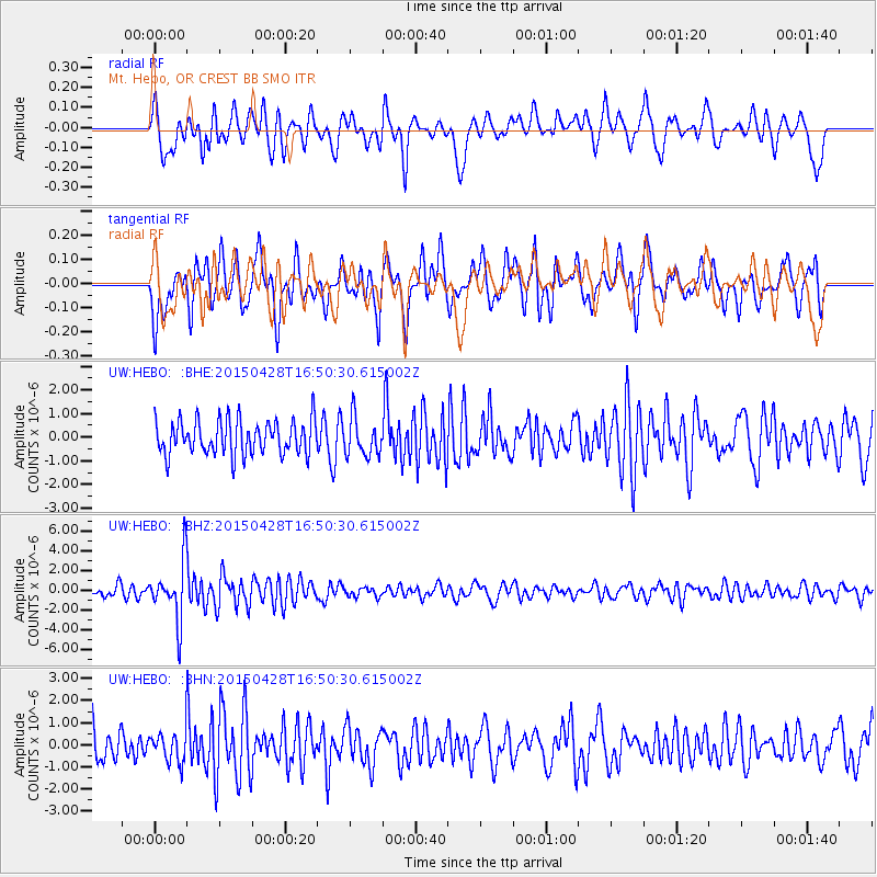
HEBO Mt. Hebo, OR CREST BB SMO - Earthquake Result Viewer
*The percent match for this event was below the threshold and hence no stack was calculated.
| Earthquake location: |
Fiji Islands Region |
| Earthquake latitude/longitude: |
-20.9/-178.7 |
| Earthquake time(UTC): |
2015/04/28 (118) 16:39:38 GMT |
| Earthquake Depth: |
579 km |
| Earthquake Magnitude: |
6.2 MWB |
| Earthquake Catalog/Contributor: |
NEIC PDE/NEIC COMCAT |
|
| Network: |
UW Pacific Northwest Regional Seismic Network |
| Station: |
HEBO Mt. Hebo, OR CREST BB SMO |
| Lat/Lon: |
45.21 N/123.76 W |
| Elevation: |
875 m |
|
| Distance: |
82.6 deg |
| Az: |
35.674 deg |
| Baz: |
230.473 deg |
| Ray Param: |
$rayparam |
*The percent match for this event was below the threshold and hence was not used in the summary stack. |
|
| Radial Match: |
59.205482 % |
| Radial Bump: |
396 |
| Transverse Match: |
71.7978 % |
| Transverse Bump: |
400 |
| SOD ConfigId: |
7422571 |
| Insert Time: |
2019-04-18 13:56:51.846 +0000 |
| GWidth: |
2.5 |
| Max Bumps: |
400 |
| Tol: |
0.001 |
|
Signal To Noise
| Channel | StoN | STA | LTA |
| UW:HEBO: :BHZ:20150428T16:50:30.615002Z | 5.689668 | 3.0056199E-6 | 5.2825925E-7 |
| UW:HEBO: :BHN:20150428T16:50:30.615002Z | 0.9569652 | 6.7488565E-7 | 7.052353E-7 |
| UW:HEBO: :BHE:20150428T16:50:30.615002Z | 1.1003917 | 8.0149334E-7 | 7.2837094E-7 |
| Arrivals |
| Ps | |
| PpPs | |
| PsPs/PpSs | |


