You are here: Home > Network List > TA - USArray Transportable Network (new EarthScope stations) Stations List
> Station Q58A Fox Den Farm, The Plains, VA, USA > Earthquake Result Viewer
Q58A Fox Den Farm, The Plains, VA, USA - Earthquake Result Viewer
| Earthquake location: |
Iceland |
| Earthquake latitude/longitude: |
64.7/-17.5 |
| Earthquake time(UTC): |
2014/09/01 (244) 11:41:10 GMT |
| Earthquake Depth: |
10 km |
| Earthquake Magnitude: |
5.5 MWW, 5.5 MWC |
| Earthquake Catalog/Contributor: |
NEIC PDE/NEIC COMCAT |
|
| Network: |
TA USArray Transportable Network (new EarthScope stations) |
| Station: |
Q58A Fox Den Farm, The Plains, VA, USA |
| Lat/Lon: |
38.94 N/77.68 W |
| Elevation: |
182 m |
|
| Distance: |
43.0 deg |
| Az: |
263.194 deg |
| Baz: |
33.196 deg |
| Ray Param: |
0.07285617 |
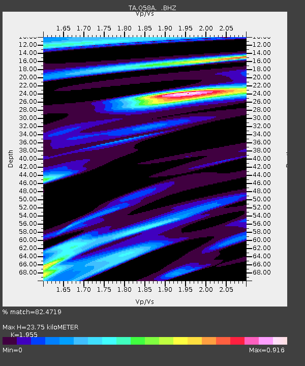
| Estimated Moho Depth: |
23.75 km |
| Estimated Crust Vp/Vs: |
1.96 |
| Assumed Crust Vp: |
6.419 km/s |
| Estimated Crust Vs: |
3.283 km/s |
| Estimated Crust Poisson's Ratio: |
0.32 |
|
| Radial Match: |
82.4719 % |
| Radial Bump: |
330 |
| Transverse Match: |
70.69139 % |
| Transverse Bump: |
400 |
| SOD ConfigId: |
796777 |
| Insert Time: |
2014-10-09 14:39:03.980 +0000 |
| GWidth: |
2.5 |
| Max Bumps: |
400 |
| Tol: |
0.001 |
|

Signal To Noise
| Channel | StoN | STA | LTA |
| TA:Q58A: :BHZ:20140901T11:48:39.075006Z | 5.1712265 | 4.0130143E-7 | 7.7602756E-8 |
| TA:Q58A: :BHN:20140901T11:48:39.075006Z | 2.1468635 | 1.9881351E-7 | 9.260649E-8 |
| TA:Q58A: :BHE:20140901T11:48:39.075006Z | 2.1560638 | 2.278272E-7 | 1.0566811E-7 |
| Arrivals |
| Ps | 3.8 SECOND |
| PpPs | 10 SECOND |
| PsPs/PpSs | 14 SECOND |


