You are here: Home > Network List > TA - USArray Transportable Network (new EarthScope stations) Stations List
> Station R54A Victor, WV, USA > Earthquake Result Viewer
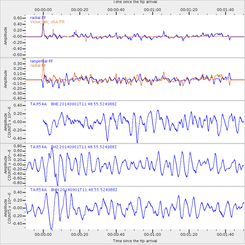
R54A Victor, WV, USA - Earthquake Result Viewer
*The percent match for this event was below the threshold and hence no stack was calculated.
| Earthquake location: |
Iceland |
| Earthquake latitude/longitude: |
64.7/-17.5 |
| Earthquake time(UTC): |
2014/09/01 (244) 11:41:10 GMT |
| Earthquake Depth: |
10 km |
| Earthquake Magnitude: |
5.5 MWW, 5.5 MWC |
| Earthquake Catalog/Contributor: |
NEIC PDE/NEIC COMCAT |
|
| Network: |
TA USArray Transportable Network (new EarthScope stations) |
| Station: |
R54A Victor, WV, USA |
| Lat/Lon: |
38.18 N/80.99 W |
| Elevation: |
512 m |
|
| Distance: |
45.0 deg |
| Az: |
265.727 deg |
| Baz: |
32.964 deg |
| Ray Param: |
$rayparam |
*The percent match for this event was below the threshold and hence was not used in the summary stack. |
|
| Radial Match: |
60.2525 % |
| Radial Bump: |
400 |
| Transverse Match: |
57.89583 % |
| Transverse Bump: |
400 |
| SOD ConfigId: |
796777 |
| Insert Time: |
2014-10-09 14:39:16.949 +0000 |
| GWidth: |
2.5 |
| Max Bumps: |
400 |
| Tol: |
0.001 |
|
Signal To Noise
| Channel | StoN | STA | LTA |
| TA:R54A: :BHZ:20140901T11:48:55.524988Z | 2.7408469 | 4.3076864E-7 | 1.5716626E-7 |
| TA:R54A: :BHN:20140901T11:48:55.524988Z | 3.597686 | 2.9440656E-7 | 8.18322E-8 |
| TA:R54A: :BHE:20140901T11:48:55.524988Z | 0.98335797 | 1.0986798E-7 | 1.1172735E-7 |
| Arrivals |
| Ps | |
| PpPs | |
| PsPs/PpSs | |


