You are here: Home > Network List > TA - USArray Transportable Network (new EarthScope stations) Stations List
> Station Y57A Sumter, SC, USA > Earthquake Result Viewer
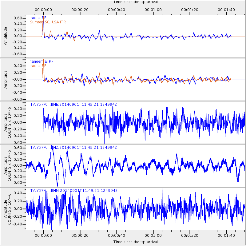
Y57A Sumter, SC, USA - Earthquake Result Viewer
*The percent match for this event was below the threshold and hence no stack was calculated.
| Earthquake location: |
Iceland |
| Earthquake latitude/longitude: |
64.7/-17.5 |
| Earthquake time(UTC): |
2014/09/01 (244) 11:41:10 GMT |
| Earthquake Depth: |
10 km |
| Earthquake Magnitude: |
5.5 MWW, 5.5 MWC |
| Earthquake Catalog/Contributor: |
NEIC PDE/NEIC COMCAT |
|
| Network: |
TA USArray Transportable Network (new EarthScope stations) |
| Station: |
Y57A Sumter, SC, USA |
| Lat/Lon: |
34.02 N/80.39 W |
| Elevation: |
56 m |
|
| Distance: |
48.3 deg |
| Az: |
262.14 deg |
| Baz: |
30.852 deg |
| Ray Param: |
$rayparam |
*The percent match for this event was below the threshold and hence was not used in the summary stack. |
|
| Radial Match: |
73.03442 % |
| Radial Bump: |
400 |
| Transverse Match: |
50.281902 % |
| Transverse Bump: |
400 |
| SOD ConfigId: |
796777 |
| Insert Time: |
2014-10-09 14:42:18.089 +0000 |
| GWidth: |
2.5 |
| Max Bumps: |
400 |
| Tol: |
0.001 |
|
Signal To Noise
| Channel | StoN | STA | LTA |
| TA:Y57A: :BHZ:20140901T11:49:21.124994Z | 2.9157388 | 3.0653752E-7 | 1.0513202E-7 |
| TA:Y57A: :BHN:20140901T11:49:21.124994Z | 1.8383244 | 2.3957907E-7 | 1.303247E-7 |
| TA:Y57A: :BHE:20140901T11:49:21.124994Z | 1.347547 | 2.026686E-7 | 1.5039817E-7 |
| Arrivals |
| Ps | |
| PpPs | |
| PsPs/PpSs | |


