You are here: Home > Network List > US - United States National Seismic Network Stations List
> Station DGMT Dagmar, Montana, USA > Earthquake Result Viewer
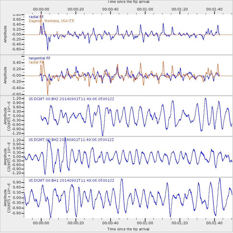
DGMT Dagmar, Montana, USA - Earthquake Result Viewer
*The percent match for this event was below the threshold and hence no stack was calculated.
| Earthquake location: |
Iceland |
| Earthquake latitude/longitude: |
64.7/-17.5 |
| Earthquake time(UTC): |
2014/09/01 (244) 11:41:10 GMT |
| Earthquake Depth: |
10 km |
| Earthquake Magnitude: |
5.5 MWW, 5.5 MWC |
| Earthquake Catalog/Contributor: |
NEIC PDE/NEIC COMCAT |
|
| Network: |
US United States National Seismic Network |
| Station: |
DGMT Dagmar, Montana, USA |
| Lat/Lon: |
48.47 N/104.20 W |
| Elevation: |
0.0 m |
|
| Distance: |
46.3 deg |
| Az: |
293.325 deg |
| Baz: |
36.393 deg |
| Ray Param: |
$rayparam |
*The percent match for this event was below the threshold and hence was not used in the summary stack. |
|
| Radial Match: |
73.61437 % |
| Radial Bump: |
400 |
| Transverse Match: |
58.193485 % |
| Transverse Bump: |
400 |
| SOD ConfigId: |
796777 |
| Insert Time: |
2014-10-09 14:44:08.476 +0000 |
| GWidth: |
2.5 |
| Max Bumps: |
400 |
| Tol: |
0.001 |
|
Signal To Noise
| Channel | StoN | STA | LTA |
| US:DGMT:00:BHZ:20140901T11:49:06.050012Z | 4.2129855 | 7.2826987E-7 | 1.7286314E-7 |
| US:DGMT:00:BH1:20140901T11:49:06.050012Z | 1.3496046 | 3.7010022E-7 | 2.7422863E-7 |
| US:DGMT:00:BH2:20140901T11:49:06.050012Z | 1.5994002 | 4.5813678E-7 | 2.8644286E-7 |
| Arrivals |
| Ps | |
| PpPs | |
| PsPs/PpSs | |


