You are here: Home > Network List > UW - Pacific Northwest Regional Seismic Network Stations List
> Station UMAT Pilot Rock, OR, USA > Earthquake Result Viewer
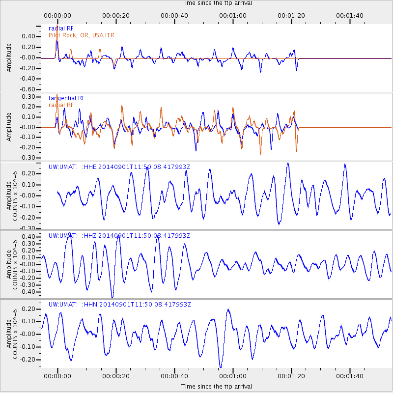
UMAT Pilot Rock, OR, USA - Earthquake Result Viewer
*The percent match for this event was below the threshold and hence no stack was calculated.
| Earthquake location: |
Iceland |
| Earthquake latitude/longitude: |
64.7/-17.5 |
| Earthquake time(UTC): |
2014/09/01 (244) 11:41:10 GMT |
| Earthquake Depth: |
10 km |
| Earthquake Magnitude: |
5.5 MWW, 5.5 MWC |
| Earthquake Catalog/Contributor: |
NEIC PDE/NEIC COMCAT |
|
| Network: |
UW Pacific Northwest Regional Seismic Network |
| Station: |
UMAT Pilot Rock, OR, USA |
| Lat/Lon: |
45.29 N/118.96 W |
| Elevation: |
1318 m |
|
| Distance: |
54.6 deg |
| Az: |
301.946 deg |
| Baz: |
31.124 deg |
| Ray Param: |
$rayparam |
*The percent match for this event was below the threshold and hence was not used in the summary stack. |
|
| Radial Match: |
64.58257 % |
| Radial Bump: |
400 |
| Transverse Match: |
49.554756 % |
| Transverse Bump: |
400 |
| SOD ConfigId: |
796777 |
| Insert Time: |
2014-10-09 14:48:33.058 +0000 |
| GWidth: |
2.5 |
| Max Bumps: |
400 |
| Tol: |
0.001 |
|
Signal To Noise
| Channel | StoN | STA | LTA |
| UW:UMAT: :HHZ:20140901T11:50:08.417993Z | 3.9813874 | 2.6897771E-7 | 6.755879E-8 |
| UW:UMAT: :HHN:20140901T11:50:08.417993Z | 1.383696 | 1.2261E-7 | 8.8610506E-8 |
| UW:UMAT: :HHE:20140901T11:50:08.417993Z | 2.0289402 | 1.6092298E-7 | 7.9313814E-8 |
| Arrivals |
| Ps | |
| PpPs | |
| PsPs/PpSs | |


