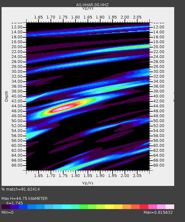
HHAR Hobbs,AR - Earthquake Result Viewer

Earthquake location: Southern Alaska
Earthquake latitude/longitude: 62.0/-151.8
Earthquake time(UTC): 2014/09/25 (268) 17:51:17 GMT
Earthquake Depth: 103 km
Earthquake Magnitude: 6.2 ML, 6.1 MI, 6.2 MWW, 6.3 MWR, 6.3 MWB, 6.3 MWC
Earthquake Catalog/Contributor: NEIC PDE/NEIC COMCAT
Network: AG Arkansas Seismic Network
Station: HHAR Hobbs,AR
Lat/Lon: 36.28 N/93.94 W
Elevation: 421 m
Distance: 43.7 deg
Az: 98.356 deg
Baz: 324.636 deg
Ray Param: 0.07200127
Estimated Moho Depth: 44.75 km
Estimated Crust Vp/Vs: 1.75
Assumed Crust Vp: 6.53 km/s
Estimated Crust Vs: 3.742 km/s
Estimated Crust Poisson's Ratio: 0.26
Radial Match: 91.62414 %
Radial Bump: 400
Transverse Match: 68.62512 %
Transverse Bump: 400
SOD ConfigId: 796777
Insert Time: 2014-10-09 17:56:34.795 +0000
GWidth: 2.5
Max Bumps: 400
Tol: 0.001

Signal To Noise

ChannelStoNSTALTA
AG:HHAR:00:HHZ:20140925T17:58:41.679993Z4.67273868.52377E-71.8241487E-7
AG:HHAR:00:HHN:20140925T17:58:41.679993Z3.92150163.9737014E-71.0133112E-7
AG:HHAR:00:HHE:20140925T17:58:41.679993Z2.14649062.5662803E-71.1955701E-7
Arrivals
Ps5.5 SECOND
PpPs18 SECOND
PsPs/PpSs23 SECOND