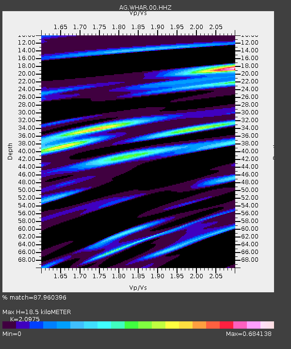
WHAR Woolly Hollow State Park,AR - Earthquake Result Viewer

Earthquake location: Southern Alaska
Earthquake latitude/longitude: 62.0/-151.8
Earthquake time(UTC): 2014/09/25 (268) 17:51:17 GMT
Earthquake Depth: 103 km
Earthquake Magnitude: 6.2 ML, 6.1 MI, 6.2 MWW, 6.3 MWR, 6.3 MWB, 6.3 MWC
Earthquake Catalog/Contributor: NEIC PDE/NEIC COMCAT
Network: AG Arkansas Seismic Network
Station: WHAR Woolly Hollow State Park,AR
Lat/Lon: 35.29 N/92.29 W
Elevation: 184 m
Distance: 45.3 deg
Az: 97.604 deg
Baz: 325.061 deg
Ray Param: 0.07099549
Estimated Moho Depth: 18.5 km
Estimated Crust Vp/Vs: 2.10
Assumed Crust Vp: 6.498 km/s
Estimated Crust Vs: 3.098 km/s
Estimated Crust Poisson's Ratio: 0.35
Radial Match: 87.960396 %
Radial Bump: 370
Transverse Match: 55.995564 %
Transverse Bump: 400
SOD ConfigId: 796777
Insert Time: 2014-10-09 17:56:40.157 +0000
GWidth: 2.5
Max Bumps: 400
Tol: 0.001

Signal To Noise

ChannelStoNSTALTA
AG:WHAR:00:HHZ:20140925T17:58:54.225006Z4.23168567.7890445E-71.8406482E-7
AG:WHAR:00:HHN:20140925T17:58:54.225006Z1.79277313.560782E-71.9861866E-7
AG:WHAR:00:HHE:20140925T17:58:54.225006Z1.35840683.0394028E-72.2374762E-7
Arrivals
Ps3.3 SECOND
PpPs8.4 SECOND
PsPs/PpSs12 SECOND