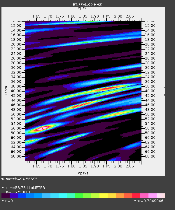
FPAL Fort Payne,AL - Earthquake Result Viewer

Earthquake location: Southern Alaska
Earthquake latitude/longitude: 62.0/-151.8
Earthquake time(UTC): 2014/09/25 (268) 17:51:17 GMT
Earthquake Depth: 103 km
Earthquake Magnitude: 6.2 ML, 6.1 MI, 6.2 MWW, 6.3 MWR, 6.3 MWB, 6.3 MWC
Earthquake Catalog/Contributor: NEIC PDE/NEIC COMCAT
Network: ET CERI Southern Appalachian seismic Network
Station: FPAL Fort Payne,AL
Lat/Lon: 34.54 N/85.61 W
Elevation: 556 m
Distance: 49.1 deg
Az: 92.055 deg
Baz: 325.096 deg
Ray Param: 0.06859589
Estimated Moho Depth: 55.75 km
Estimated Crust Vp/Vs: 1.68
Assumed Crust Vp: 6.35 km/s
Estimated Crust Vs: 3.791 km/s
Estimated Crust Poisson's Ratio: 0.22
Radial Match: 94.56595 %
Radial Bump: 356
Transverse Match: 70.600975 %
Transverse Bump: 400
SOD ConfigId: 796777
Insert Time: 2014-10-09 18:02:36.934 +0000
GWidth: 2.5
Max Bumps: 400
Tol: 0.001

Signal To Noise

ChannelStoNSTALTA
ET:FPAL:00:HHZ:20140925T17:59:23.334991Z9.76437951.5224833E-61.5592218E-7
ET:FPAL:00:HHN:20140925T17:59:23.334991Z4.48866276.517611E-71.4520162E-7
ET:FPAL:00:HHE:20140925T17:59:23.334991Z3.19564584.8157835E-71.5069828E-7
Arrivals
Ps6.3 SECOND
PpPs22 SECOND
PsPs/PpSs28 SECOND