You are here: Home > Network List > US - United States National Seismic Network Stations List
> Station WMOK Wichita Mountains, Oklahoma, USA > Earthquake Result Viewer
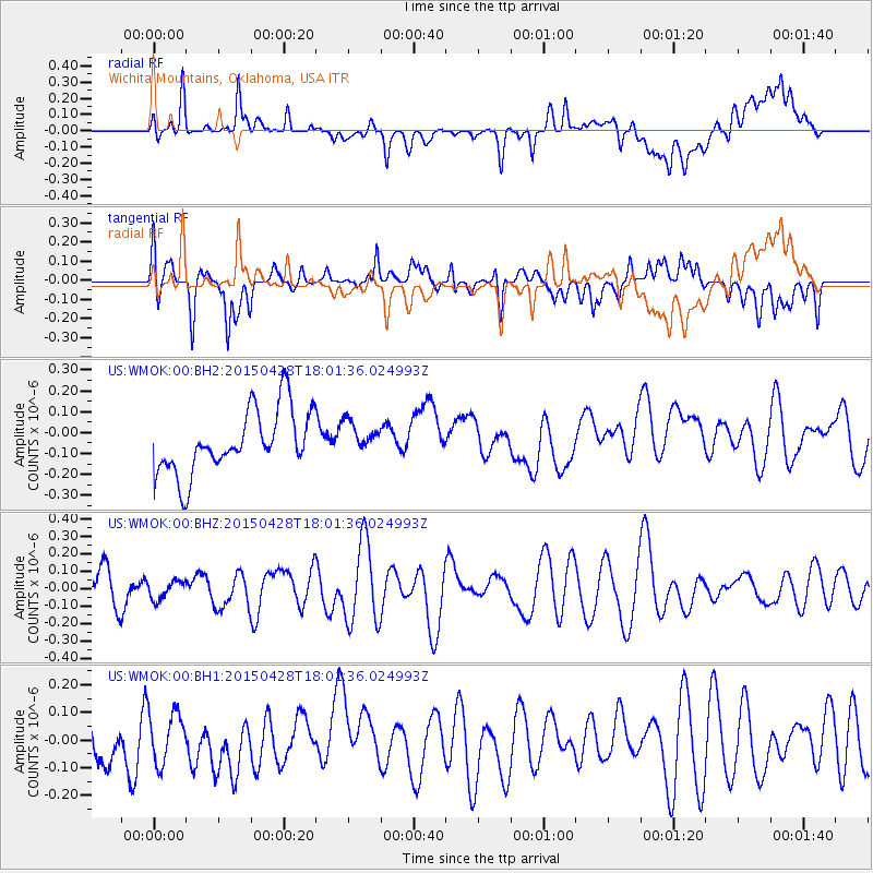
WMOK Wichita Mountains, Oklahoma, USA - Earthquake Result Viewer
*The percent match for this event was below the threshold and hence no stack was calculated.
| Earthquake location: |
Hokkaido, Japan Region |
| Earthquake latitude/longitude: |
43.2/145.9 |
| Earthquake time(UTC): |
2015/04/28 (118) 17:49:49 GMT |
| Earthquake Depth: |
51 km |
| Earthquake Magnitude: |
4.5 mb, 4.3 mb |
| Earthquake Catalog/Contributor: |
ISC/ISC |
|
| Network: |
US United States National Seismic Network |
| Station: |
WMOK Wichita Mountains, Oklahoma, USA |
| Lat/Lon: |
34.74 N/98.78 W |
| Elevation: |
486 m |
|
| Distance: |
82.6 deg |
| Az: |
48.672 deg |
| Baz: |
318.178 deg |
| Ray Param: |
$rayparam |
*The percent match for this event was below the threshold and hence was not used in the summary stack. |
|
| Radial Match: |
44.3323 % |
| Radial Bump: |
400 |
| Transverse Match: |
66.05345 % |
| Transverse Bump: |
400 |
| SOD ConfigId: |
7422571 |
| Insert Time: |
2019-04-18 14:05:11.360 +0000 |
| GWidth: |
2.5 |
| Max Bumps: |
400 |
| Tol: |
0.001 |
|
Signal To Noise
| Channel | StoN | STA | LTA |
| US:WMOK:00:BHZ:20150428T18:01:36.024993Z | 0.4285523 | 5.2287543E-8 | 1.2200972E-7 |
| US:WMOK:00:BH1:20150428T18:01:36.024993Z | 1.0737431 | 8.886886E-8 | 8.2765474E-8 |
| US:WMOK:00:BH2:20150428T18:01:36.024993Z | 0.49924743 | 7.503013E-8 | 1.5028647E-7 |
| Arrivals |
| Ps | |
| PpPs | |
| PsPs/PpSs | |


