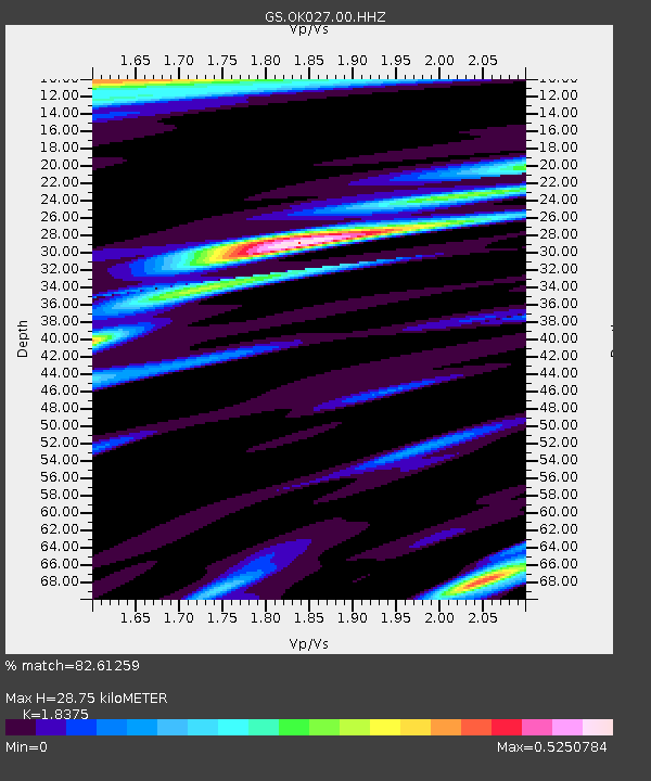
OK027 Henny and Sorgum Hills Rd. - Earthquake Result Viewer

Earthquake location: Southern Alaska
Earthquake latitude/longitude: 62.0/-151.8
Earthquake time(UTC): 2014/09/25 (268) 17:51:17 GMT
Earthquake Depth: 103 km
Earthquake Magnitude: 6.2 ML, 6.1 MI, 6.2 MWW, 6.3 MWR, 6.3 MWB, 6.3 MWC
Earthquake Catalog/Contributor: NEIC PDE/NEIC COMCAT
Network: GS US Geological Survey Networks
Station: OK027 Henny and Sorgum Hills Rd.
Lat/Lon: 35.71 N/97.28 W
Elevation: 364 m
Distance: 42.7 deg
Az: 102.078 deg
Baz: 325.393 deg
Ray Param: 0.07269316
Estimated Moho Depth: 28.75 km
Estimated Crust Vp/Vs: 1.84
Assumed Crust Vp: 6.426 km/s
Estimated Crust Vs: 3.497 km/s
Estimated Crust Poisson's Ratio: 0.29
Radial Match: 82.61259 %
Radial Bump: 354
Transverse Match: 60.05753 %
Transverse Bump: 400
SOD ConfigId: 796777
Insert Time: 2014-10-09 18:04:51.833 +0000
GWidth: 2.5
Max Bumps: 400
Tol: 0.001

Signal To Noise

ChannelStoNSTALTA
GS:OK027:00:HHZ:20140925T17:58:32.938995Z11.8715461.8112456E-61.5257034E-7
GS:OK027:00:HH1:20140925T17:58:32.938995Z3.07992585.3456233E-71.7356338E-7
GS:OK027:00:HH2:20140925T17:58:32.938995Z1.58047435.0216164E-73.1772845E-7
Arrivals
Ps4.0 SECOND
PpPs12 SECOND
PsPs/PpSs16 SECOND