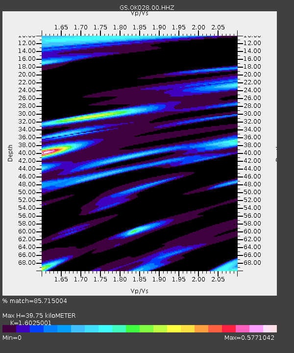
OK028 N Oak Rd and Britton Rd, Lincoln County - Earthquake Result Viewer

Earthquake location: Southern Alaska
Earthquake latitude/longitude: 62.0/-151.8
Earthquake time(UTC): 2014/09/25 (268) 17:51:17 GMT
Earthquake Depth: 103 km
Earthquake Magnitude: 6.2 ML, 6.1 MI, 6.2 MWW, 6.3 MWR, 6.3 MWB, 6.3 MWC
Earthquake Catalog/Contributor: NEIC PDE/NEIC COMCAT
Network: GS US Geological Survey Networks
Station: OK028 N Oak Rd and Britton Rd, Lincoln County
Lat/Lon: 35.56 N/97.06 W
Elevation: 330 m
Distance: 42.9 deg
Az: 101.984 deg
Baz: 325.453 deg
Ray Param: 0.072548576
Estimated Moho Depth: 39.75 km
Estimated Crust Vp/Vs: 1.60
Assumed Crust Vp: 6.426 km/s
Estimated Crust Vs: 4.01 km/s
Estimated Crust Poisson's Ratio: 0.18
Radial Match: 85.715004 %
Radial Bump: 300
Transverse Match: 65.56008 %
Transverse Bump: 366
SOD ConfigId: 796777
Insert Time: 2014-10-09 18:04:53.377 +0000
GWidth: 2.5
Max Bumps: 400
Tol: 0.001

Signal To Noise

ChannelStoNSTALTA
GS:OK028:00:HHZ:20140925T17:58:34.76001Z7.33994671.6443008E-62.2402081E-7
GS:OK028:00:HH1:20140925T17:58:34.76001Z0.879989863.772685E-74.2871912E-7
GS:OK028:00:HH2:20140925T17:58:34.76001Z2.3262887.375835E-73.1706455E-7
Arrivals
Ps4.0 SECOND
PpPs15 SECOND
PsPs/PpSs19 SECOND