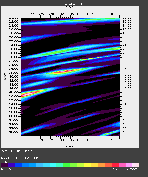
TUPA Temple University, Pennsylvania - Earthquake Result Viewer
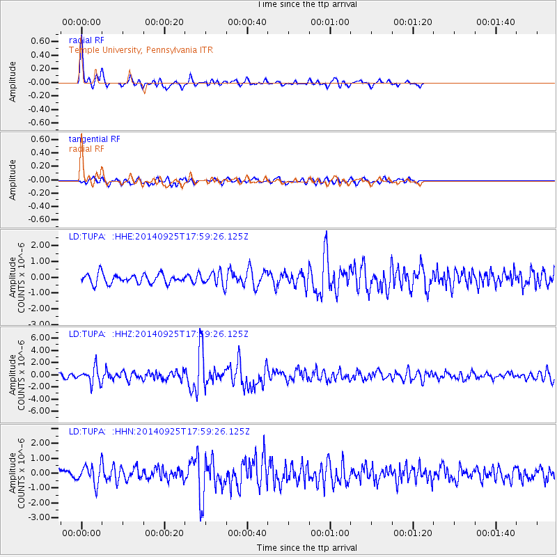
Earthquake location: Southern Alaska
Earthquake latitude/longitude: 62.0/-151.8
Earthquake time(UTC): 2014/09/25 (268) 17:51:17 GMT
Earthquake Depth: 103 km
Earthquake Magnitude: 6.2 ML, 6.1 MI, 6.2 MWW, 6.3 MWR, 6.3 MWB, 6.3 MWC
Earthquake Catalog/Contributor: NEIC PDE/NEIC COMCAT
Network: LD Lamont-Doherty Cooperative Seismographic Network
Station: TUPA Temple University, Pennsylvania
Lat/Lon: 40.17 N/75.19 W
Elevation: 112 m
Distance: 49.4 deg
Az: 78.833 deg
Baz: 322.762 deg
Ray Param: 0.06836363
Estimated Moho Depth: 48.75 km
Estimated Crust Vp/Vs: 1.63
Assumed Crust Vp: 6.283 km/s
Estimated Crust Vs: 3.855 km/s
Estimated Crust Poisson's Ratio: 0.20
Radial Match: 84.78449 %
Radial Bump: 316
Transverse Match: 58.950043 %
Transverse Bump: 400
SOD ConfigId: 796777
Insert Time: 2014-10-09 18:12:00.114 +0000
GWidth: 2.5
Max Bumps: 400
Tol: 0.001

Signal To Noise

ChannelStoNSTALTA
LD:TUPA: :HHZ:20140925T17:59:26.125Z3.6750861.3073902E-63.5574413E-7
LD:TUPA: :HHN:20140925T17:59:26.125Z3.45842396.3477734E-71.8354527E-7
LD:TUPA: :HHE:20140925T17:59:26.125Z1.44543494.2921954E-72.9694837E-7
Arrivals
Ps5.2 SECOND
PpPs19 SECOND
PsPs/PpSs24 SECOND