You are here: Home > Network List > N4 - Central and EAstern US Network Stations List
> Station D41A Chassel, MI, USA > Earthquake Result Viewer
D41A Chassel, MI, USA - Earthquake Result Viewer
| Earthquake location: |
Southern Alaska |
| Earthquake latitude/longitude: |
62.0/-151.8 |
| Earthquake time(UTC): |
2014/09/25 (268) 17:51:17 GMT |
| Earthquake Depth: |
103 km |
| Earthquake Magnitude: |
6.2 ML, 6.1 MI, 6.2 MWW, 6.3 MWR, 6.3 MWB, 6.3 MWC |
| Earthquake Catalog/Contributor: |
NEIC PDE/NEIC COMCAT |
|
| Network: |
N4 Central and EAstern US Network |
| Station: |
D41A Chassel, MI, USA |
| Lat/Lon: |
47.06 N/88.57 W |
| Elevation: |
271 m |
|
| Distance: |
37.9 deg |
| Az: |
83.135 deg |
| Baz: |
316.654 deg |
| Ray Param: |
0.07550641 |
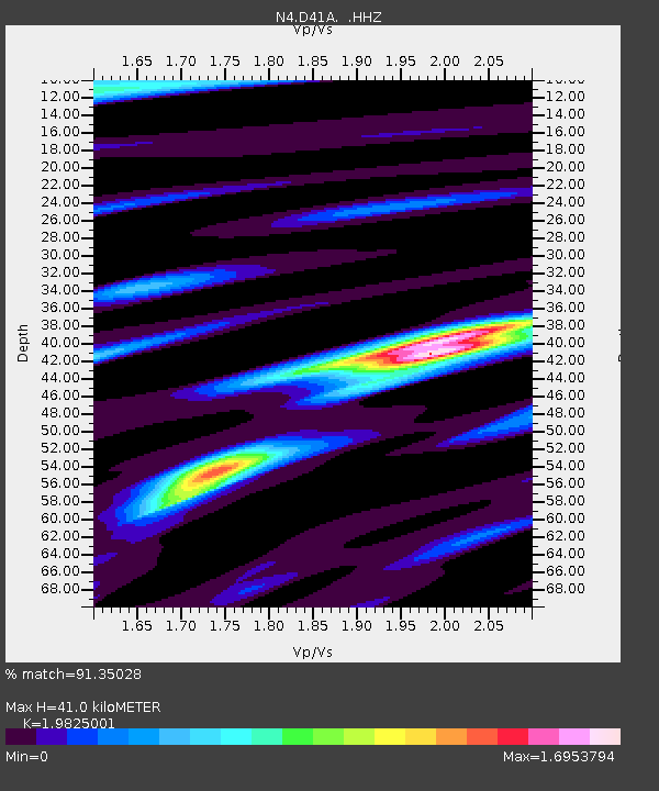
| Estimated Moho Depth: |
41.0 km |
| Estimated Crust Vp/Vs: |
1.98 |
| Assumed Crust Vp: |
6.467 km/s |
| Estimated Crust Vs: |
3.262 km/s |
| Estimated Crust Poisson's Ratio: |
0.33 |
|
| Radial Match: |
91.35028 % |
| Radial Bump: |
267 |
| Transverse Match: |
70.39365 % |
| Transverse Bump: |
339 |
| SOD ConfigId: |
796777 |
| Insert Time: |
2014-10-09 18:13:54.115 +0000 |
| GWidth: |
2.5 |
| Max Bumps: |
400 |
| Tol: |
0.001 |
|

Signal To Noise
| Channel | StoN | STA | LTA |
| N4:D41A: :HHZ:20140925T17:57:54.100006Z | 3.7475893 | 1.7096883E-6 | 4.5621016E-7 |
| N4:D41A: :HHN:20140925T17:57:54.100006Z | 1.4899571 | 5.9180627E-7 | 3.9719683E-7 |
| N4:D41A: :HHE:20140925T17:57:54.100006Z | 2.2233078 | 6.7335907E-7 | 3.028636E-7 |
| Arrivals |
| Ps | 6.6 SECOND |
| PpPs | 18 SECOND |
| PsPs/PpSs | 24 SECOND |


