You are here: Home > Network List > TA - USArray Transportable Network (new EarthScope stations) Stations List
> Station I23K Minto, Yukon-Koyukuk, AK, USA > Earthquake Result Viewer
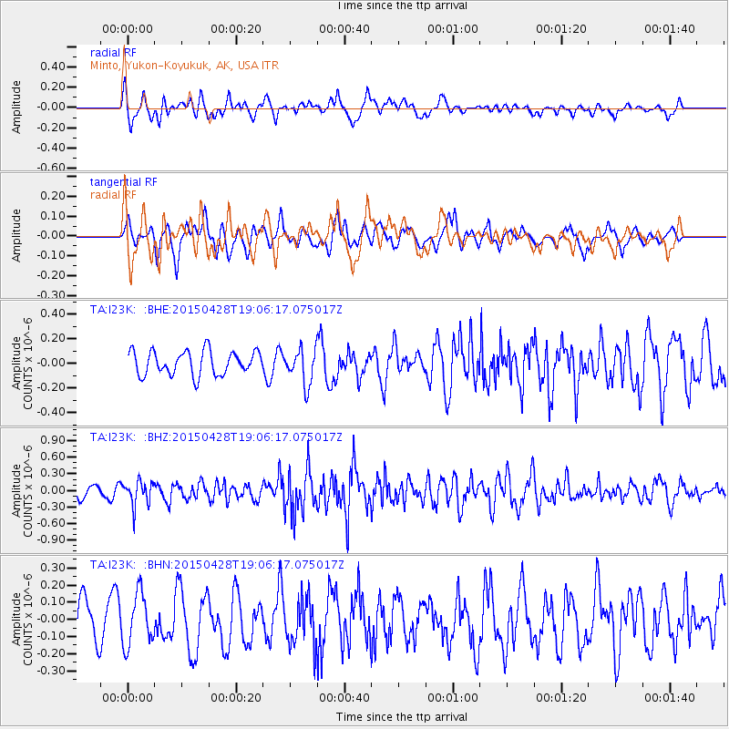
I23K Minto, Yukon-Koyukuk, AK, USA - Earthquake Result Viewer
*The percent match for this event was below the threshold and hence no stack was calculated.
| Earthquake location: |
Chiapas, Mexico |
| Earthquake latitude/longitude: |
17.2/-95.0 |
| Earthquake time(UTC): |
2015/04/28 (118) 18:56:53 GMT |
| Earthquake Depth: |
110 km |
| Earthquake Magnitude: |
5.5 MWR |
| Earthquake Catalog/Contributor: |
NEIC PDE/NEIC COMCAT |
|
| Network: |
TA USArray Transportable Network (new EarthScope stations) |
| Station: |
I23K Minto, Yukon-Koyukuk, AK, USA |
| Lat/Lon: |
65.15 N/149.36 W |
| Elevation: |
149 m |
|
| Distance: |
59.9 deg |
| Az: |
336.61 deg |
| Baz: |
116.086 deg |
| Ray Param: |
$rayparam |
*The percent match for this event was below the threshold and hence was not used in the summary stack. |
|
| Radial Match: |
63.981297 % |
| Radial Bump: |
400 |
| Transverse Match: |
42.88008 % |
| Transverse Bump: |
400 |
| SOD ConfigId: |
7422571 |
| Insert Time: |
2019-04-18 14:10:20.480 +0000 |
| GWidth: |
2.5 |
| Max Bumps: |
400 |
| Tol: |
0.001 |
|
Signal To Noise
| Channel | StoN | STA | LTA |
| TA:I23K: :BHZ:20150428T19:06:17.075017Z | 2.1627054 | 2.1879293E-7 | 1.0116632E-7 |
| TA:I23K: :BHN:20150428T19:06:17.075017Z | 1.4300599 | 1.5316235E-7 | 1.07102046E-7 |
| TA:I23K: :BHE:20150428T19:06:17.075017Z | 1.7645423 | 1.6913589E-7 | 9.5852556E-8 |
| Arrivals |
| Ps | |
| PpPs | |
| PsPs/PpSs | |


