You are here: Home > Network List > N4 - Central and EAstern US Network Stations List
> Station T42B Van Buren, MO, USA > Earthquake Result Viewer
T42B Van Buren, MO, USA - Earthquake Result Viewer
| Earthquake location: |
Southern Alaska |
| Earthquake latitude/longitude: |
62.0/-151.8 |
| Earthquake time(UTC): |
2014/09/25 (268) 17:51:17 GMT |
| Earthquake Depth: |
103 km |
| Earthquake Magnitude: |
6.2 ML, 6.1 MI, 6.2 MWW, 6.3 MWR, 6.3 MWB, 6.3 MWC |
| Earthquake Catalog/Contributor: |
NEIC PDE/NEIC COMCAT |
|
| Network: |
N4 Central and EAstern US Network |
| Station: |
T42B Van Buren, MO, USA |
| Lat/Lon: |
37.03 N/91.09 W |
| Elevation: |
165 m |
|
| Distance: |
44.5 deg |
| Az: |
95.059 deg |
| Baz: |
323.961 deg |
| Ray Param: |
0.07155034 |
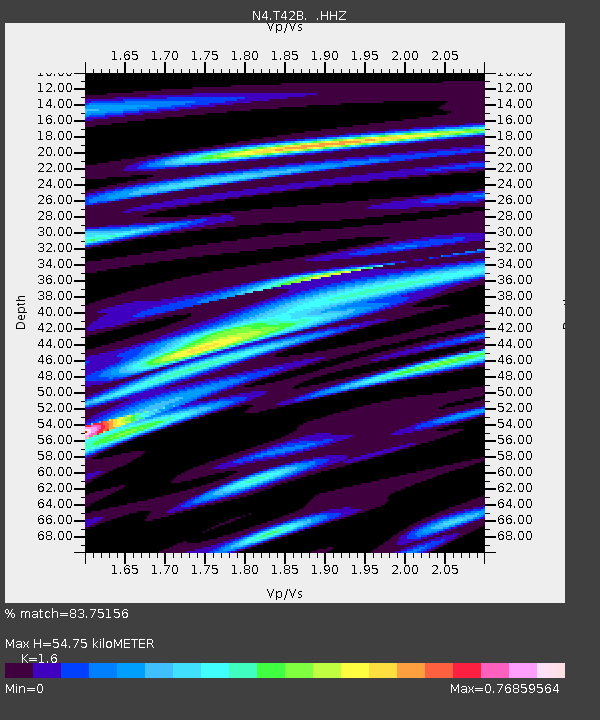
| Estimated Moho Depth: |
54.75 km |
| Estimated Crust Vp/Vs: |
1.60 |
| Assumed Crust Vp: |
6.53 km/s |
| Estimated Crust Vs: |
4.082 km/s |
| Estimated Crust Poisson's Ratio: |
0.18 |
|
| Radial Match: |
83.75156 % |
| Radial Bump: |
390 |
| Transverse Match: |
58.0159 % |
| Transverse Bump: |
400 |
| SOD ConfigId: |
796777 |
| Insert Time: |
2014-10-09 18:16:02.829 +0000 |
| GWidth: |
2.5 |
| Max Bumps: |
400 |
| Tol: |
0.001 |
|

Signal To Noise
| Channel | StoN | STA | LTA |
| N4:T42B: :HHZ:20140925T17:58:47.48999Z | 3.447531 | 8.529699E-7 | 2.474147E-7 |
| N4:T42B: :HHN:20140925T17:58:47.48999Z | 3.5732126 | 5.4290007E-7 | 1.5193612E-7 |
| N4:T42B: :HHE:20140925T17:58:47.48999Z | 1.8885988 | 3.1624884E-7 | 1.6745156E-7 |
| Arrivals |
| Ps | 5.4 SECOND |
| PpPs | 20 SECOND |
| PsPs/PpSs | 26 SECOND |


