You are here: Home > Network List > N4 - Central and EAstern US Network Stations List
> Station N47A Urbana, IN, USA > Earthquake Result Viewer
N47A Urbana, IN, USA - Earthquake Result Viewer
| Earthquake location: |
Southern Alaska |
| Earthquake latitude/longitude: |
62.0/-151.8 |
| Earthquake time(UTC): |
2014/09/25 (268) 17:51:17 GMT |
| Earthquake Depth: |
103 km |
| Earthquake Magnitude: |
6.2 ML, 6.1 MI, 6.2 MWW, 6.3 MWR, 6.3 MWB, 6.3 MWC |
| Earthquake Catalog/Contributor: |
NEIC PDE/NEIC COMCAT |
|
| Network: |
N4 Central and EAstern US Network |
| Station: |
N47A Urbana, IN, USA |
| Lat/Lon: |
40.88 N/85.69 W |
| Elevation: |
252 m |
|
| Distance: |
44.0 deg |
| Az: |
86.916 deg |
| Baz: |
321.504 deg |
| Ray Param: |
0.07186606 |
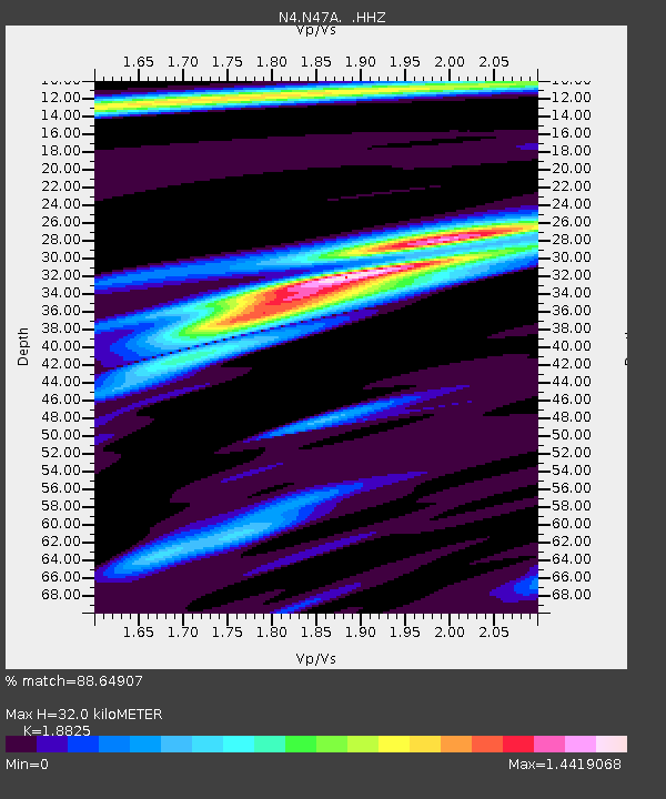
| Estimated Moho Depth: |
32.0 km |
| Estimated Crust Vp/Vs: |
1.88 |
| Assumed Crust Vp: |
6.498 km/s |
| Estimated Crust Vs: |
3.452 km/s |
| Estimated Crust Poisson's Ratio: |
0.30 |
|
| Radial Match: |
88.64907 % |
| Radial Bump: |
257 |
| Transverse Match: |
68.059425 % |
| Transverse Bump: |
358 |
| SOD ConfigId: |
796777 |
| Insert Time: |
2014-10-09 18:17:30.861 +0000 |
| GWidth: |
2.5 |
| Max Bumps: |
400 |
| Tol: |
0.001 |
|

Signal To Noise
| Channel | StoN | STA | LTA |
| N4:N47A: :HHZ:20140925T17:58:43.440002Z | 8.143944 | 1.7440357E-6 | 2.1415124E-7 |
| N4:N47A: :HHN:20140925T17:58:43.440002Z | 3.1481073 | 6.9610235E-7 | 2.2111773E-7 |
| N4:N47A: :HHE:20140925T17:58:43.440002Z | 2.0808804 | 5.286966E-7 | 2.540735E-7 |
| Arrivals |
| Ps | 4.6 SECOND |
| PpPs | 13 SECOND |
| PsPs/PpSs | 18 SECOND |


