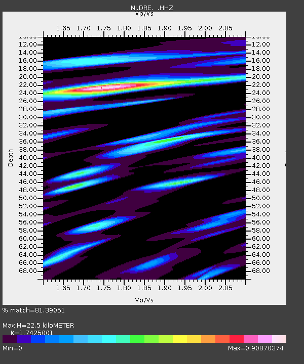
DRE Drenchia - Earthquake Result Viewer

Earthquake location: Southern Alaska
Earthquake latitude/longitude: 62.0/-151.8
Earthquake time(UTC): 2014/09/25 (268) 17:51:17 GMT
Earthquake Depth: 103 km
Earthquake Magnitude: 6.2 ML, 6.1 MI, 6.2 MWW, 6.3 MWR, 6.3 MWB, 6.3 MWC
Earthquake Catalog/Contributor: NEIC PDE/NEIC COMCAT
Network: NI North-East Italy Broadband Network
Station: DRE Drenchia
Lat/Lon: 46.17 N/13.65 E
Elevation: 810 m
Distance: 71.6 deg
Az: 10.617 deg
Baz: 352.801 deg
Ray Param: 0.05397169
Estimated Moho Depth: 22.5 km
Estimated Crust Vp/Vs: 1.74
Assumed Crust Vp: 6.35 km/s
Estimated Crust Vs: 3.644 km/s
Estimated Crust Poisson's Ratio: 0.25
Radial Match: 81.39051 %
Radial Bump: 400
Transverse Match: 67.678505 %
Transverse Bump: 400
SOD ConfigId: 796777
Insert Time: 2014-10-09 18:19:13.677 +0000
GWidth: 2.5
Max Bumps: 400
Tol: 0.001

Signal To Noise

ChannelStoNSTALTA
NI:DRE: :HHZ:20140925T18:01:56.268005Z10.9266818.642468E-77.9095095E-8
NI:DRE: :HHN:20140925T18:01:56.268005Z3.70123084.83055E-71.3051199E-7
NI:DRE: :HHE:20140925T18:01:56.268005Z3.6084583.1726145E-78.792162E-8
Arrivals
Ps2.7 SECOND
PpPs9.4 SECOND
PsPs/PpSs12 SECOND