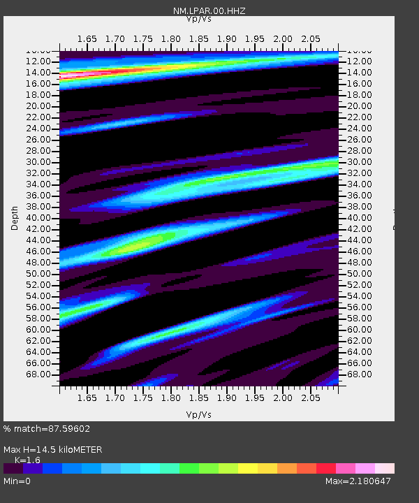
LPAR Lepanto,AR - Earthquake Result Viewer

Earthquake location: Southern Alaska
Earthquake latitude/longitude: 62.0/-151.8
Earthquake time(UTC): 2014/09/25 (268) 17:51:17 GMT
Earthquake Depth: 103 km
Earthquake Magnitude: 6.2 ML, 6.1 MI, 6.2 MWW, 6.3 MWR, 6.3 MWB, 6.3 MWC
Earthquake Catalog/Contributor: NEIC PDE/NEIC COMCAT
Network: NM Cooperative New Madrid Seismic Network
Station: LPAR Lepanto,AR
Lat/Lon: 35.60 N/90.30 W
Elevation: 67 m
Distance: 46.0 deg
Az: 95.496 deg
Baz: 324.736 deg
Ray Param: 0.07057743
Estimated Moho Depth: 14.5 km
Estimated Crust Vp/Vs: 1.60
Assumed Crust Vp: 6.273 km/s
Estimated Crust Vs: 3.921 km/s
Estimated Crust Poisson's Ratio: 0.18
Radial Match: 87.59602 %
Radial Bump: 379
Transverse Match: 55.338978 %
Transverse Bump: 400
SOD ConfigId: 796777
Insert Time: 2014-10-09 18:19:49.499 +0000
GWidth: 2.5
Max Bumps: 400
Tol: 0.001

Signal To Noise

ChannelStoNSTALTA
NM:LPAR:00:HHZ:20140925T17:58:59.570007Z6.8317872.432678E-63.5608224E-7
NM:LPAR:00:HHN:20140925T17:58:59.570007Z1.05601149.2720194E-78.7802266E-7
NM:LPAR:00:HHE:20140925T17:58:59.570007Z0.841294178.477792E-71.0077084E-6
Arrivals
Ps1.5 SECOND
PpPs5.6 SECOND
PsPs/PpSs7.1 SECOND