You are here: Home > Network List > PB - Plate Boundary Observatory Borehole Seismic Network Stations List
> Station B081 keenwi081bcs2006, Anza, CA, USA > Earthquake Result Viewer
B081 keenwi081bcs2006, Anza, CA, USA - Earthquake Result Viewer
| Earthquake location: |
Southern Alaska |
| Earthquake latitude/longitude: |
62.0/-151.8 |
| Earthquake time(UTC): |
2014/09/25 (268) 17:51:17 GMT |
| Earthquake Depth: |
103 km |
| Earthquake Magnitude: |
6.2 ML, 6.1 MI, 6.2 MWW, 6.3 MWR, 6.3 MWB, 6.3 MWC |
| Earthquake Catalog/Contributor: |
NEIC PDE/NEIC COMCAT |
|
| Network: |
PB Plate Boundary Observatory Borehole Seismic Network |
| Station: |
B081 keenwi081bcs2006, Anza, CA, USA |
| Lat/Lon: |
33.71 N/116.71 W |
| Elevation: |
1467 m |
|
| Distance: |
36.0 deg |
| Az: |
125.378 deg |
| Baz: |
332.462 deg |
| Ray Param: |
0.076598994 |
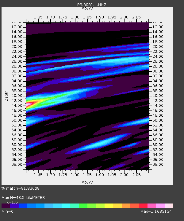
| Estimated Moho Depth: |
43.5 km |
| Estimated Crust Vp/Vs: |
1.60 |
| Assumed Crust Vp: |
6.264 km/s |
| Estimated Crust Vs: |
3.915 km/s |
| Estimated Crust Poisson's Ratio: |
0.18 |
|
| Radial Match: |
81.83608 % |
| Radial Bump: |
400 |
| Transverse Match: |
80.826454 % |
| Transverse Bump: |
400 |
| SOD ConfigId: |
796777 |
| Insert Time: |
2014-10-09 18:21:52.234 +0000 |
| GWidth: |
2.5 |
| Max Bumps: |
400 |
| Tol: |
0.001 |
|

Signal To Noise
| Channel | StoN | STA | LTA |
| PB:B081: :HHZ:20140925T17:57:37.523987Z | 5.3734813 | 1.6950368E-8 | 3.1544483E-9 |
| PB:B081: :HH1:20140925T17:57:37.523987Z | 1.0302756 | 1.1319383E-9 | 1.0986753E-9 |
| PB:B081: :HH2:20140925T17:57:37.523987Z | 2.520465 | 6.70364E-9 | 2.6596838E-9 |
| Arrivals |
| Ps | 4.5 SECOND |
| PpPs | 17 SECOND |
| PsPs/PpSs | 21 SECOND |


