You are here: Home > Network List > TA - USArray Transportable Network (new EarthScope stations) Stations List
> Station F60A Warwick, QC, CAN > Earthquake Result Viewer
F60A Warwick, QC, CAN - Earthquake Result Viewer
| Earthquake location: |
Southern Alaska |
| Earthquake latitude/longitude: |
62.0/-151.8 |
| Earthquake time(UTC): |
2014/09/25 (268) 17:51:17 GMT |
| Earthquake Depth: |
103 km |
| Earthquake Magnitude: |
6.2 ML, 6.1 MI, 6.2 MWW, 6.3 MWR, 6.3 MWB, 6.3 MWC |
| Earthquake Catalog/Contributor: |
NEIC PDE/NEIC COMCAT |
|
| Network: |
TA USArray Transportable Network (new EarthScope stations) |
| Station: |
F60A Warwick, QC, CAN |
| Lat/Lon: |
45.97 N/71.95 W |
| Elevation: |
229 m |
|
| Distance: |
46.4 deg |
| Az: |
71.46 deg |
| Baz: |
320.02 deg |
| Ray Param: |
0.07032618 |
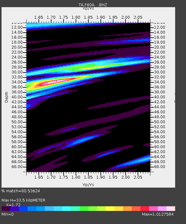
| Estimated Moho Depth: |
33.5 km |
| Estimated Crust Vp/Vs: |
1.72 |
| Assumed Crust Vp: |
6.419 km/s |
| Estimated Crust Vs: |
3.732 km/s |
| Estimated Crust Poisson's Ratio: |
0.24 |
|
| Radial Match: |
80.53624 % |
| Radial Bump: |
397 |
| Transverse Match: |
69.472305 % |
| Transverse Bump: |
400 |
| SOD ConfigId: |
796777 |
| Insert Time: |
2014-10-09 18:26:34.432 +0000 |
| GWidth: |
2.5 |
| Max Bumps: |
400 |
| Tol: |
0.001 |
|
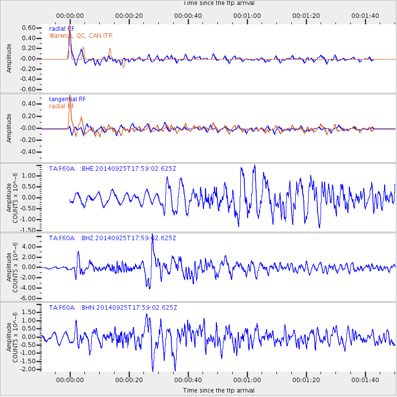
Signal To Noise
| Channel | StoN | STA | LTA |
| TA:F60A: :BHZ:20140925T17:59:02.625Z | 4.708419 | 1.2379587E-6 | 2.6292452E-7 |
| TA:F60A: :BHN:20140925T17:59:02.625Z | 2.5312517 | 3.9029266E-7 | 1.5418959E-7 |
| TA:F60A: :BHE:20140925T17:59:02.625Z | 2.3509417 | 4.7455174E-7 | 2.0185604E-7 |
| Arrivals |
| Ps | 4.0 SECOND |
| PpPs | 13 SECOND |
| PsPs/PpSs | 17 SECOND |


