You are here: Home > Network List > TA - USArray Transportable Network (new EarthScope stations) Stations List
> Station G55A Calabogie, ON, CAN > Earthquake Result Viewer
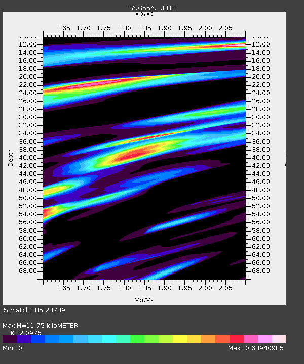
G55A Calabogie, ON, CAN - Earthquake Result Viewer
| Earthquake location: |
Southern Alaska |
| Earthquake latitude/longitude: |
62.0/-151.8 |
| Earthquake time(UTC): |
2014/09/25 (268) 17:51:17 GMT |
| Earthquake Depth: |
103 km |
| Earthquake Magnitude: |
6.2 ML, 6.1 MI, 6.2 MWW, 6.3 MWR, 6.3 MWB, 6.3 MWC |
| Earthquake Catalog/Contributor: |
NEIC PDE/NEIC COMCAT |
|
| Network: |
TA USArray Transportable Network (new EarthScope stations) |
| Station: |
G55A Calabogie, ON, CAN |
| Lat/Lon: |
45.25 N/76.72 W |
| Elevation: |
228 m |
|
| Distance: |
44.8 deg |
| Az: |
75.684 deg |
| Baz: |
319.581 deg |
| Ray Param: |
0.07134925 |
| Estimated Moho Depth: |
11.75 km |
| Estimated Crust Vp/Vs: |
2.10 |
| Assumed Crust Vp: |
6.577 km/s |
| Estimated Crust Vs: |
3.136 km/s |
| Estimated Crust Poisson's Ratio: |
0.35 |
|
| Radial Match: |
85.28789 % |
| Radial Bump: |
329 |
| Transverse Match: |
70.146286 % |
| Transverse Bump: |
400 |
| SOD ConfigId: |
796777 |
| Insert Time: |
2014-10-09 18:26:50.050 +0000 |
| GWidth: |
2.5 |
| Max Bumps: |
400 |
| Tol: |
0.001 |
|

Signal To Noise
| Channel | StoN | STA | LTA |
| TA:G55A: :BHZ:20140925T17:58:49.924988Z | 4.4935937 | 1.254505E-6 | 2.7917633E-7 |
| TA:G55A: :BHN:20140925T17:58:49.924988Z | 2.2030191 | 6.7489236E-7 | 3.0634885E-7 |
| TA:G55A: :BHE:20140925T17:58:49.924988Z | 2.6437235 | 4.2855353E-7 | 1.6210225E-7 |
| Arrivals |
| Ps | 2.1 SECOND |
| PpPs | 5.2 SECOND |
| PsPs/PpSs | 7.3 SECOND |


