You are here: Home > Network List > TA - USArray Transportable Network (new EarthScope stations) Stations List
> Station G61A St-Isidore-de-Clifton, QC, USA > Earthquake Result Viewer
G61A St-Isidore-de-Clifton, QC, USA - Earthquake Result Viewer
| Earthquake location: |
Southern Alaska |
| Earthquake latitude/longitude: |
62.0/-151.8 |
| Earthquake time(UTC): |
2014/09/25 (268) 17:51:17 GMT |
| Earthquake Depth: |
103 km |
| Earthquake Magnitude: |
6.2 ML, 6.1 MI, 6.2 MWW, 6.3 MWR, 6.3 MWB, 6.3 MWC |
| Earthquake Catalog/Contributor: |
NEIC PDE/NEIC COMCAT |
|
| Network: |
TA USArray Transportable Network (new EarthScope stations) |
| Station: |
G61A St-Isidore-de-Clifton, QC, USA |
| Lat/Lon: |
45.28 N/71.53 W |
| Elevation: |
378 m |
|
| Distance: |
47.1 deg |
| Az: |
71.748 deg |
| Baz: |
320.519 deg |
| Ray Param: |
0.06985641 |
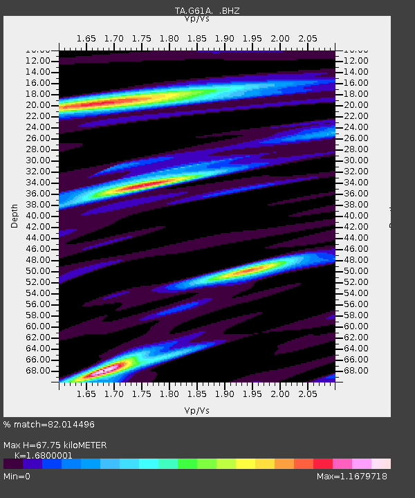
| Estimated Moho Depth: |
67.75 km |
| Estimated Crust Vp/Vs: |
1.68 |
| Assumed Crust Vp: |
6.419 km/s |
| Estimated Crust Vs: |
3.821 km/s |
| Estimated Crust Poisson's Ratio: |
0.23 |
|
| Radial Match: |
82.014496 % |
| Radial Bump: |
400 |
| Transverse Match: |
64.93943 % |
| Transverse Bump: |
400 |
| SOD ConfigId: |
796777 |
| Insert Time: |
2014-10-09 18:27:01.091 +0000 |
| GWidth: |
2.5 |
| Max Bumps: |
400 |
| Tol: |
0.001 |
|

Signal To Noise
| Channel | StoN | STA | LTA |
| TA:G61A: :BHZ:20140925T17:59:08.200012Z | 4.006173 | 8.835278E-7 | 2.205416E-7 |
| TA:G61A: :BHN:20140925T17:59:08.200012Z | 2.8768945 | 5.166869E-7 | 1.7959884E-7 |
| TA:G61A: :BHE:20140925T17:59:08.200012Z | 2.0126555 | 5.5408003E-7 | 2.75298E-7 |
| Arrivals |
| Ps | 7.7 SECOND |
| PpPs | 27 SECOND |
| PsPs/PpSs | 34 SECOND |


