You are here: Home > Network List > TA - USArray Transportable Network (new EarthScope stations) Stations List
> Station G64A Maxfield, ME, USA > Earthquake Result Viewer
G64A Maxfield, ME, USA - Earthquake Result Viewer
| Earthquake location: |
Southern Alaska |
| Earthquake latitude/longitude: |
62.0/-151.8 |
| Earthquake time(UTC): |
2014/09/25 (268) 17:51:17 GMT |
| Earthquake Depth: |
103 km |
| Earthquake Magnitude: |
6.2 ML, 6.1 MI, 6.2 MWW, 6.3 MWR, 6.3 MWB, 6.3 MWC |
| Earthquake Catalog/Contributor: |
NEIC PDE/NEIC COMCAT |
|
| Network: |
TA USArray Transportable Network (new EarthScope stations) |
| Station: |
G64A Maxfield, ME, USA |
| Lat/Lon: |
45.25 N/68.76 W |
| Elevation: |
165 m |
|
| Distance: |
48.4 deg |
| Az: |
69.724 deg |
| Baz: |
321.12 deg |
| Ray Param: |
0.069055274 |
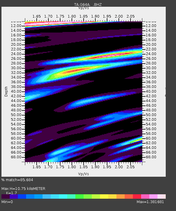
| Estimated Moho Depth: |
10.75 km |
| Estimated Crust Vp/Vs: |
1.70 |
| Assumed Crust Vp: |
6.419 km/s |
| Estimated Crust Vs: |
3.776 km/s |
| Estimated Crust Poisson's Ratio: |
0.24 |
|
| Radial Match: |
85.684 % |
| Radial Bump: |
400 |
| Transverse Match: |
70.40663 % |
| Transverse Bump: |
400 |
| SOD ConfigId: |
796777 |
| Insert Time: |
2014-10-09 18:27:11.327 +0000 |
| GWidth: |
2.5 |
| Max Bumps: |
400 |
| Tol: |
0.001 |
|

Signal To Noise
| Channel | StoN | STA | LTA |
| TA:G64A: :BHZ:20140925T17:59:17.924988Z | 6.5709476 | 1.2553919E-6 | 1.9105188E-7 |
| TA:G64A: :BHN:20140925T17:59:17.924988Z | 4.6519523 | 5.595261E-7 | 1.202777E-7 |
| TA:G64A: :BHE:20140925T17:59:17.924988Z | 1.8603201 | 4.719111E-7 | 2.53672E-7 |
| Arrivals |
| Ps | 1.2 SECOND |
| PpPs | 4.2 SECOND |
| PsPs/PpSs | 5.5 SECOND |


