You are here: Home > Network List > TA - USArray Transportable Network (new EarthScope stations) Stations List
> Station I63A Otisfield, ME, USA > Earthquake Result Viewer
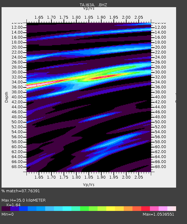
I63A Otisfield, ME, USA - Earthquake Result Viewer
| Earthquake location: |
Southern Alaska |
| Earthquake latitude/longitude: |
62.0/-151.8 |
| Earthquake time(UTC): |
2014/09/25 (268) 17:51:17 GMT |
| Earthquake Depth: |
103 km |
| Earthquake Magnitude: |
6.2 ML, 6.1 MI, 6.2 MWW, 6.3 MWR, 6.3 MWB, 6.3 MWC |
| Earthquake Catalog/Contributor: |
NEIC PDE/NEIC COMCAT |
|
| Network: |
TA USArray Transportable Network (new EarthScope stations) |
| Station: |
I63A Otisfield, ME, USA |
| Lat/Lon: |
44.05 N/70.58 W |
| Elevation: |
177 m |
|
| Distance: |
48.5 deg |
| Az: |
72.087 deg |
| Baz: |
321.41 deg |
| Ray Param: |
0.06897391 |
| Estimated Moho Depth: |
35.0 km |
| Estimated Crust Vp/Vs: |
1.64 |
| Assumed Crust Vp: |
6.419 km/s |
| Estimated Crust Vs: |
3.914 km/s |
| Estimated Crust Poisson's Ratio: |
0.20 |
|
| Radial Match: |
87.76391 % |
| Radial Bump: |
315 |
| Transverse Match: |
60.237614 % |
| Transverse Bump: |
400 |
| SOD ConfigId: |
796777 |
| Insert Time: |
2014-10-09 18:28:04.269 +0000 |
| GWidth: |
2.5 |
| Max Bumps: |
400 |
| Tol: |
0.001 |
|

Signal To Noise
| Channel | StoN | STA | LTA |
| TA:I63A: :BHZ:20140925T17:59:18.850006Z | 5.526036 | 9.898478E-7 | 1.7912438E-7 |
| TA:I63A: :BHN:20140925T17:59:18.850006Z | 2.745886 | 5.2156014E-7 | 1.8994238E-7 |
| TA:I63A: :BHE:20140925T17:59:18.850006Z | 1.6753775 | 3.956679E-7 | 2.3616643E-7 |
| Arrivals |
| Ps | 3.7 SECOND |
| PpPs | 13 SECOND |
| PsPs/PpSs | 17 SECOND |


