You are here: Home > Network List > TA - USArray Transportable Network (new EarthScope stations) Stations List
> Station 121A Cookes Peak, Deming, NM, USA > Earthquake Result Viewer
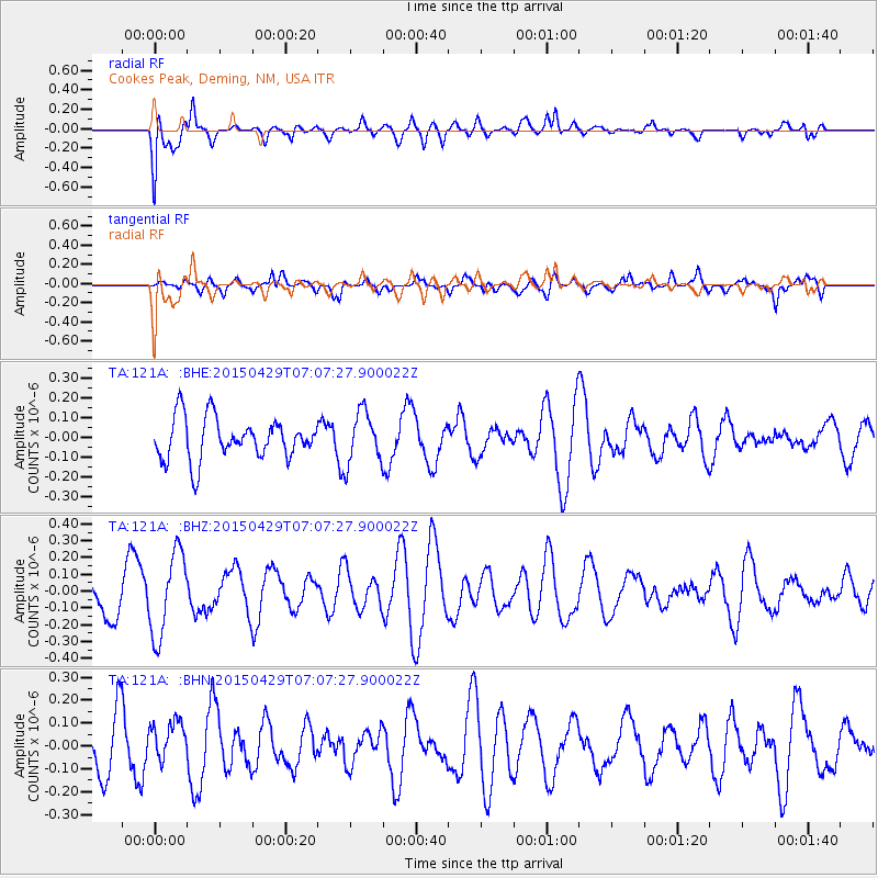
121A Cookes Peak, Deming, NM, USA - Earthquake Result Viewer
*The percent match for this event was below the threshold and hence no stack was calculated.
| Earthquake location: |
Kermadec Islands Region |
| Earthquake latitude/longitude: |
-31.5/-177.0 |
| Earthquake time(UTC): |
2015/04/29 (119) 06:54:57 GMT |
| Earthquake Depth: |
35 km |
| Earthquake Magnitude: |
4.9 MW, 5.0 mb |
| Earthquake Catalog/Contributor: |
ISC/ISC |
|
| Network: |
TA USArray Transportable Network (new EarthScope stations) |
| Station: |
121A Cookes Peak, Deming, NM, USA |
| Lat/Lon: |
32.53 N/107.79 W |
| Elevation: |
1652 m |
|
| Distance: |
91.3 deg |
| Az: |
52.177 deg |
| Baz: |
233.031 deg |
| Ray Param: |
$rayparam |
*The percent match for this event was below the threshold and hence was not used in the summary stack. |
|
| Radial Match: |
66.91809 % |
| Radial Bump: |
400 |
| Transverse Match: |
57.260956 % |
| Transverse Bump: |
400 |
| SOD ConfigId: |
7422571 |
| Insert Time: |
2019-04-18 14:19:27.024 +0000 |
| GWidth: |
2.5 |
| Max Bumps: |
400 |
| Tol: |
0.001 |
|
Signal To Noise
| Channel | StoN | STA | LTA |
| TA:121A: :BHZ:20150429T07:07:27.900022Z | 1.9480121 | 2.479165E-7 | 1.272664E-7 |
| TA:121A: :BHN:20150429T07:07:27.900022Z | 0.90573716 | 8.3781636E-8 | 9.250105E-8 |
| TA:121A: :BHE:20150429T07:07:27.900022Z | 1.2415105 | 1.2943694E-7 | 1.0425763E-7 |
| Arrivals |
| Ps | |
| PpPs | |
| PsPs/PpSs | |


