You are here: Home > Network List > TA - USArray Transportable Network (new EarthScope stations) Stations List
> Station J60A Lant Hill Farm, Argyle, NY, USA > Earthquake Result Viewer
J60A Lant Hill Farm, Argyle, NY, USA - Earthquake Result Viewer
| Earthquake location: |
Southern Alaska |
| Earthquake latitude/longitude: |
62.0/-151.8 |
| Earthquake time(UTC): |
2014/09/25 (268) 17:51:17 GMT |
| Earthquake Depth: |
103 km |
| Earthquake Magnitude: |
6.2 ML, 6.1 MI, 6.2 MWW, 6.3 MWR, 6.3 MWB, 6.3 MWC |
| Earthquake Catalog/Contributor: |
NEIC PDE/NEIC COMCAT |
|
| Network: |
TA USArray Transportable Network (new EarthScope stations) |
| Station: |
J60A Lant Hill Farm, Argyle, NY, USA |
| Lat/Lon: |
43.24 N/73.42 W |
| Elevation: |
265 m |
|
| Distance: |
47.8 deg |
| Az: |
74.925 deg |
| Baz: |
321.349 deg |
| Ray Param: |
0.06940833 |
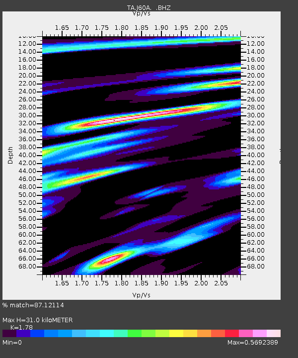
| Estimated Moho Depth: |
31.0 km |
| Estimated Crust Vp/Vs: |
1.78 |
| Assumed Crust Vp: |
6.419 km/s |
| Estimated Crust Vs: |
3.606 km/s |
| Estimated Crust Poisson's Ratio: |
0.27 |
|
| Radial Match: |
87.12114 % |
| Radial Bump: |
340 |
| Transverse Match: |
63.80058 % |
| Transverse Bump: |
388 |
| SOD ConfigId: |
796777 |
| Insert Time: |
2014-10-09 18:28:24.451 +0000 |
| GWidth: |
2.5 |
| Max Bumps: |
400 |
| Tol: |
0.001 |
|

Signal To Noise
| Channel | StoN | STA | LTA |
| TA:J60A: :BHZ:20140925T17:59:13.799988Z | 3.9555779 | 1.2623467E-6 | 3.191308E-7 |
| TA:J60A: :BHN:20140925T17:59:13.799988Z | 3.2749841 | 6.4461466E-7 | 1.9682986E-7 |
| TA:J60A: :BHE:20140925T17:59:13.799988Z | 2.0203846 | 4.5934516E-7 | 2.273553E-7 |
| Arrivals |
| Ps | 4.0 SECOND |
| PpPs | 13 SECOND |
| PsPs/PpSs | 17 SECOND |


