You are here: Home > Network List > TA - USArray Transportable Network (new EarthScope stations) Stations List
> Station K58A Earlville, NY, USA > Earthquake Result Viewer
K58A Earlville, NY, USA - Earthquake Result Viewer
| Earthquake location: |
Southern Alaska |
| Earthquake latitude/longitude: |
62.0/-151.8 |
| Earthquake time(UTC): |
2014/09/25 (268) 17:51:17 GMT |
| Earthquake Depth: |
103 km |
| Earthquake Magnitude: |
6.2 ML, 6.1 MI, 6.2 MWW, 6.3 MWR, 6.3 MWB, 6.3 MWC |
| Earthquake Catalog/Contributor: |
NEIC PDE/NEIC COMCAT |
|
| Network: |
TA USArray Transportable Network (new EarthScope stations) |
| Station: |
K58A Earlville, NY, USA |
| Lat/Lon: |
42.76 N/75.65 W |
| Elevation: |
509 m |
|
| Distance: |
47.2 deg |
| Az: |
77.06 deg |
| Baz: |
321.279 deg |
| Ray Param: |
0.06980745 |
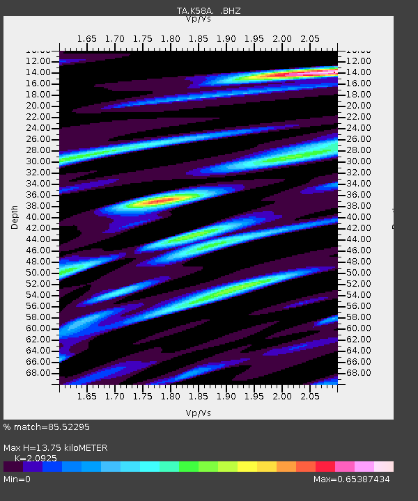
| Estimated Moho Depth: |
13.75 km |
| Estimated Crust Vp/Vs: |
2.09 |
| Assumed Crust Vp: |
6.419 km/s |
| Estimated Crust Vs: |
3.068 km/s |
| Estimated Crust Poisson's Ratio: |
0.35 |
|
| Radial Match: |
85.52295 % |
| Radial Bump: |
400 |
| Transverse Match: |
57.638905 % |
| Transverse Bump: |
400 |
| SOD ConfigId: |
796777 |
| Insert Time: |
2014-10-09 18:28:46.168 +0000 |
| GWidth: |
2.5 |
| Max Bumps: |
400 |
| Tol: |
0.001 |
|
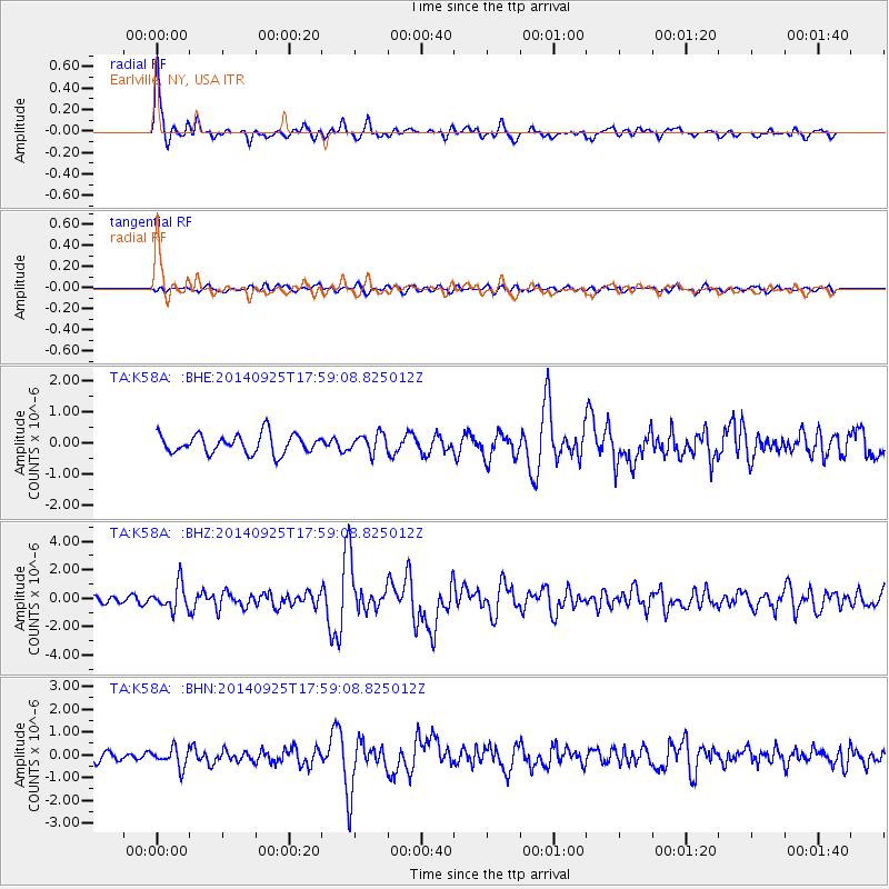
Signal To Noise
| Channel | StoN | STA | LTA |
| TA:K58A: :BHZ:20140925T17:59:08.825012Z | 4.173587 | 9.0341723E-7 | 2.1646062E-7 |
| TA:K58A: :BHN:20140925T17:59:08.825012Z | 1.7374688 | 4.1655238E-7 | 2.3974667E-7 |
| TA:K58A: :BHE:20140925T17:59:08.825012Z | 0.9777202 | 3.006406E-7 | 3.0749146E-7 |
| Arrivals |
| Ps | 2.5 SECOND |
| PpPs | 6.3 SECOND |
| PsPs/PpSs | 8.8 SECOND |


