You are here: Home > Network List > TA - USArray Transportable Network (new EarthScope stations) Stations List
> Station M52A Chesterland, OH, USA > Earthquake Result Viewer
M52A Chesterland, OH, USA - Earthquake Result Viewer
| Earthquake location: |
Southern Alaska |
| Earthquake latitude/longitude: |
62.0/-151.8 |
| Earthquake time(UTC): |
2014/09/25 (268) 17:51:17 GMT |
| Earthquake Depth: |
103 km |
| Earthquake Magnitude: |
6.2 ML, 6.1 MI, 6.2 MWW, 6.3 MWR, 6.3 MWB, 6.3 MWC |
| Earthquake Catalog/Contributor: |
NEIC PDE/NEIC COMCAT |
|
| Network: |
TA USArray Transportable Network (new EarthScope stations) |
| Station: |
M52A Chesterland, OH, USA |
| Lat/Lon: |
41.54 N/81.36 W |
| Elevation: |
382 m |
|
| Distance: |
45.5 deg |
| Az: |
82.697 deg |
| Baz: |
321.353 deg |
| Ray Param: |
0.070894286 |
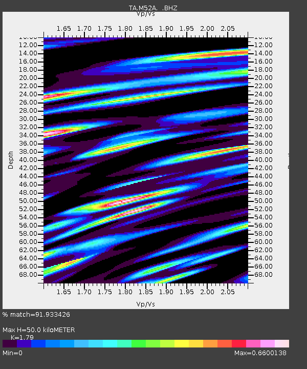
| Estimated Moho Depth: |
50.0 km |
| Estimated Crust Vp/Vs: |
1.79 |
| Assumed Crust Vp: |
6.483 km/s |
| Estimated Crust Vs: |
3.622 km/s |
| Estimated Crust Poisson's Ratio: |
0.27 |
|
| Radial Match: |
91.933426 % |
| Radial Bump: |
400 |
| Transverse Match: |
69.01464 % |
| Transverse Bump: |
400 |
| SOD ConfigId: |
796777 |
| Insert Time: |
2014-10-09 18:29:40.051 +0000 |
| GWidth: |
2.5 |
| Max Bumps: |
400 |
| Tol: |
0.001 |
|
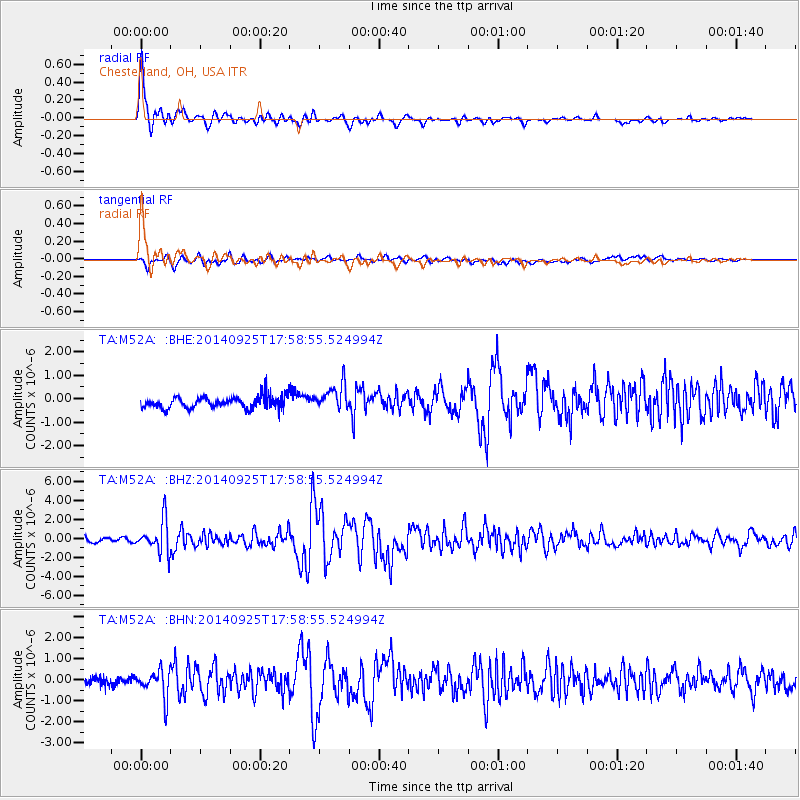
Signal To Noise
| Channel | StoN | STA | LTA |
| TA:M52A: :BHZ:20140925T17:58:55.524994Z | 6.5289216 | 1.6746261E-6 | 2.5649354E-7 |
| TA:M52A: :BHN:20140925T17:58:55.524994Z | 2.8450825 | 6.4690227E-7 | 2.2737558E-7 |
| TA:M52A: :BHE:20140925T17:58:55.524994Z | 2.1555994 | 5.445125E-7 | 2.5260374E-7 |
| Arrivals |
| Ps | 6.5 SECOND |
| PpPs | 20 SECOND |
| PsPs/PpSs | 27 SECOND |


