You are here: Home > Network List > TA - USArray Transportable Network (new EarthScope stations) Stations List
> Station M60A Port Jervis, NY, USA > Earthquake Result Viewer
M60A Port Jervis, NY, USA - Earthquake Result Viewer
| Earthquake location: |
Southern Alaska |
| Earthquake latitude/longitude: |
62.0/-151.8 |
| Earthquake time(UTC): |
2014/09/25 (268) 17:51:17 GMT |
| Earthquake Depth: |
103 km |
| Earthquake Magnitude: |
6.2 ML, 6.1 MI, 6.2 MWW, 6.3 MWR, 6.3 MWB, 6.3 MWC |
| Earthquake Catalog/Contributor: |
NEIC PDE/NEIC COMCAT |
|
| Network: |
TA USArray Transportable Network (new EarthScope stations) |
| Station: |
M60A Port Jervis, NY, USA |
| Lat/Lon: |
41.33 N/74.62 W |
| Elevation: |
292 m |
|
| Distance: |
48.8 deg |
| Az: |
77.452 deg |
| Baz: |
322.223 deg |
| Ray Param: |
0.06878023 |
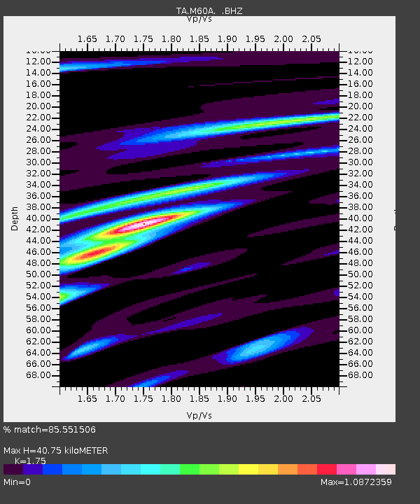
| Estimated Moho Depth: |
40.75 km |
| Estimated Crust Vp/Vs: |
1.75 |
| Assumed Crust Vp: |
6.283 km/s |
| Estimated Crust Vs: |
3.59 km/s |
| Estimated Crust Poisson's Ratio: |
0.26 |
|
| Radial Match: |
85.551506 % |
| Radial Bump: |
400 |
| Transverse Match: |
72.06455 % |
| Transverse Bump: |
400 |
| SOD ConfigId: |
796777 |
| Insert Time: |
2014-10-09 18:29:59.001 +0000 |
| GWidth: |
2.5 |
| Max Bumps: |
400 |
| Tol: |
0.001 |
|

Signal To Noise
| Channel | StoN | STA | LTA |
| TA:M60A: :BHZ:20140925T17:59:21.125Z | 3.5354397 | 1.4963368E-6 | 4.2323924E-7 |
| TA:M60A: :BHN:20140925T17:59:21.125Z | 2.2670188 | 5.8487916E-7 | 2.5799486E-7 |
| TA:M60A: :BHE:20140925T17:59:21.125Z | 2.0310862 | 5.023954E-7 | 2.4735306E-7 |
| Arrivals |
| Ps | 5.1 SECOND |
| PpPs | 17 SECOND |
| PsPs/PpSs | 22 SECOND |


