You are here: Home > Network List > TA - USArray Transportable Network (new EarthScope stations) Stations List
> Station N52A McGinn's Farm, Dalton, OH, USA > Earthquake Result Viewer
N52A McGinn's Farm, Dalton, OH, USA - Earthquake Result Viewer
| Earthquake location: |
Southern Alaska |
| Earthquake latitude/longitude: |
62.0/-151.8 |
| Earthquake time(UTC): |
2014/09/25 (268) 17:51:17 GMT |
| Earthquake Depth: |
103 km |
| Earthquake Magnitude: |
6.2 ML, 6.1 MI, 6.2 MWW, 6.3 MWR, 6.3 MWB, 6.3 MWC |
| Earthquake Catalog/Contributor: |
NEIC PDE/NEIC COMCAT |
|
| Network: |
TA USArray Transportable Network (new EarthScope stations) |
| Station: |
N52A McGinn's Farm, Dalton, OH, USA |
| Lat/Lon: |
40.81 N/81.69 W |
| Elevation: |
331 m |
|
| Distance: |
45.9 deg |
| Az: |
83.6 deg |
| Baz: |
321.768 deg |
| Ray Param: |
0.07063863 |
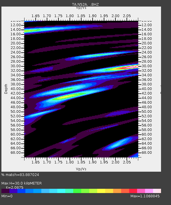
| Estimated Moho Depth: |
30.0 km |
| Estimated Crust Vp/Vs: |
2.09 |
| Assumed Crust Vp: |
6.483 km/s |
| Estimated Crust Vs: |
3.105 km/s |
| Estimated Crust Poisson's Ratio: |
0.35 |
|
| Radial Match: |
83.887024 % |
| Radial Bump: |
400 |
| Transverse Match: |
77.28732 % |
| Transverse Bump: |
400 |
| SOD ConfigId: |
796777 |
| Insert Time: |
2014-10-09 18:30:23.531 +0000 |
| GWidth: |
2.5 |
| Max Bumps: |
400 |
| Tol: |
0.001 |
|

Signal To Noise
| Channel | StoN | STA | LTA |
| TA:N52A: :BHZ:20140925T17:58:58.799988Z | 8.041925 | 1.6197331E-6 | 2.014111E-7 |
| TA:N52A: :BHN:20140925T17:58:58.799988Z | 1.5651695 | 6.0807344E-7 | 3.8850325E-7 |
| TA:N52A: :BHE:20140925T17:58:58.799988Z | 1.9831336 | 5.943878E-7 | 2.9972153E-7 |
| Arrivals |
| Ps | 5.3 SECOND |
| PpPs | 14 SECOND |
| PsPs/PpSs | 19 SECOND |


