You are here: Home > Network List > TA - USArray Transportable Network (new EarthScope stations) Stations List
> Station N57A Milroy, PA, USA > Earthquake Result Viewer
N57A Milroy, PA, USA - Earthquake Result Viewer
| Earthquake location: |
Southern Alaska |
| Earthquake latitude/longitude: |
62.0/-151.8 |
| Earthquake time(UTC): |
2014/09/25 (268) 17:51:17 GMT |
| Earthquake Depth: |
103 km |
| Earthquake Magnitude: |
6.2 ML, 6.1 MI, 6.2 MWW, 6.3 MWR, 6.3 MWB, 6.3 MWC |
| Earthquake Catalog/Contributor: |
NEIC PDE/NEIC COMCAT |
|
| Network: |
TA USArray Transportable Network (new EarthScope stations) |
| Station: |
N57A Milroy, PA, USA |
| Lat/Lon: |
40.76 N/77.55 W |
| Elevation: |
306 m |
|
| Distance: |
47.9 deg |
| Az: |
80.261 deg |
| Baz: |
322.176 deg |
| Ray Param: |
0.06937921 |
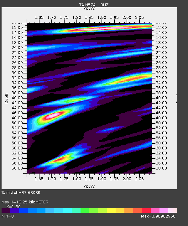
| Estimated Moho Depth: |
12.25 km |
| Estimated Crust Vp/Vs: |
1.89 |
| Assumed Crust Vp: |
6.121 km/s |
| Estimated Crust Vs: |
3.238 km/s |
| Estimated Crust Poisson's Ratio: |
0.31 |
|
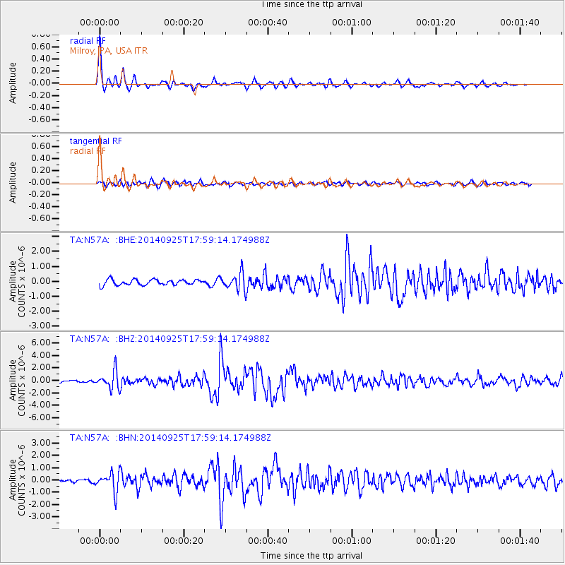
| Radial Match: |
87.68089 % |
| Radial Bump: |
326 |
| Transverse Match: |
68.2954 % |
| Transverse Bump: |
400 |
| SOD ConfigId: |
796777 |
| Insert Time: |
2014-10-09 18:30:35.294 +0000 |
| GWidth: |
2.5 |
| Max Bumps: |
400 |
| Tol: |
0.001 |
|
Signal To Noise
| Channel | StoN | STA | LTA |
| TA:N57A: :BHZ:20140925T17:59:14.174988Z | 7.9746947 | 1.4521642E-6 | 1.8209653E-7 |
| TA:N57A: :BHN:20140925T17:59:14.174988Z | 3.281535 | 7.9963536E-7 | 2.4367725E-7 |
| TA:N57A: :BHE:20140925T17:59:14.174988Z | 3.1600707 | 5.7534504E-7 | 1.8206715E-7 |
| Arrivals |
| Ps | 1.9 SECOND |
| PpPs | 5.5 SECOND |
| PsPs/PpSs | 7.4 SECOND |


