You are here: Home > Network List > TA - USArray Transportable Network (new EarthScope stations) Stations List
> Station O57A Amberson, PA, USA > Earthquake Result Viewer
O57A Amberson, PA, USA - Earthquake Result Viewer
| Earthquake location: |
Southern Alaska |
| Earthquake latitude/longitude: |
62.0/-151.8 |
| Earthquake time(UTC): |
2014/09/25 (268) 17:51:17 GMT |
| Earthquake Depth: |
103 km |
| Earthquake Magnitude: |
6.2 ML, 6.1 MI, 6.2 MWW, 6.3 MWR, 6.3 MWB, 6.3 MWC |
| Earthquake Catalog/Contributor: |
NEIC PDE/NEIC COMCAT |
|
| Network: |
TA USArray Transportable Network (new EarthScope stations) |
| Station: |
O57A Amberson, PA, USA |
| Lat/Lon: |
40.21 N/77.64 W |
| Elevation: |
377 m |
|
| Distance: |
48.3 deg |
| Az: |
80.777 deg |
| Baz: |
322.466 deg |
| Ray Param: |
0.069119096 |
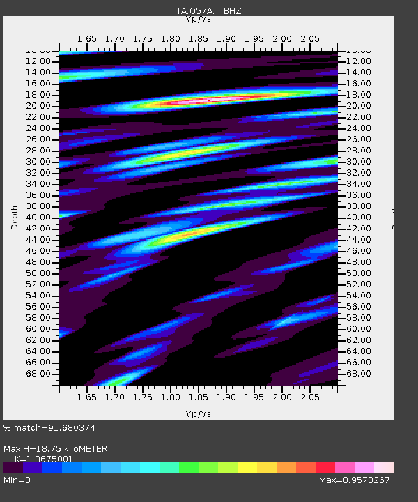
| Estimated Moho Depth: |
18.75 km |
| Estimated Crust Vp/Vs: |
1.87 |
| Assumed Crust Vp: |
6.121 km/s |
| Estimated Crust Vs: |
3.277 km/s |
| Estimated Crust Poisson's Ratio: |
0.30 |
|
| Radial Match: |
91.680374 % |
| Radial Bump: |
400 |
| Transverse Match: |
82.10603 % |
| Transverse Bump: |
400 |
| SOD ConfigId: |
796777 |
| Insert Time: |
2014-10-09 18:31:03.457 +0000 |
| GWidth: |
2.5 |
| Max Bumps: |
400 |
| Tol: |
0.001 |
|

Signal To Noise
| Channel | StoN | STA | LTA |
| TA:O57A: :BHZ:20140925T17:59:17.174988Z | 9.570383 | 2.0559376E-6 | 2.1482292E-7 |
| TA:O57A: :BHN:20140925T17:59:17.174988Z | 4.205885 | 8.229327E-7 | 1.9566221E-7 |
| TA:O57A: :BHE:20140925T17:59:17.174988Z | 3.8152049 | 6.6599176E-7 | 1.7456252E-7 |
| Arrivals |
| Ps | 2.8 SECOND |
| PpPs | 8.3 SECOND |
| PsPs/PpSs | 11 SECOND |


