You are here: Home > Network List > TA - USArray Transportable Network (new EarthScope stations) Stations List
> Station O58A Lewisberry, PA, USA > Earthquake Result Viewer
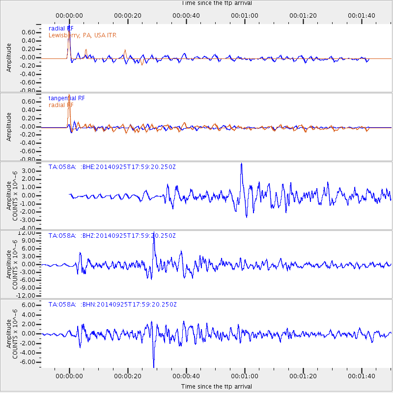
O58A Lewisberry, PA, USA - Earthquake Result Viewer

| Earthquake location: |
Southern Alaska |
| Earthquake latitude/longitude: |
62.0/-151.8 |
| Earthquake time(UTC): |
2014/09/25 (268) 17:51:17 GMT |
| Earthquake Depth: |
103 km |
| Earthquake Magnitude: |
6.2 ML, 6.1 MI, 6.2 MWW, 6.3 MWR, 6.3 MWB, 6.3 MWC |
| Earthquake Catalog/Contributor: |
NEIC PDE/NEIC COMCAT |
|
| Network: |
TA USArray Transportable Network (new EarthScope stations) |
| Station: |
O58A Lewisberry, PA, USA |
| Lat/Lon: |
40.12 N/76.92 W |
| Elevation: |
321 m |
|
| Distance: |
48.7 deg |
| Az: |
80.269 deg |
| Baz: |
322.588 deg |
| Ray Param: |
0.06885248 |
| Estimated Moho Depth: |
43.5 km |
| Estimated Crust Vp/Vs: |
1.73 |
| Assumed Crust Vp: |
6.121 km/s |
| Estimated Crust Vs: |
3.548 km/s |
| Estimated Crust Poisson's Ratio: |
0.25 |
|
| Radial Match: |
92.92804 % |
| Radial Bump: |
372 |
| Transverse Match: |
79.45754 % |
| Transverse Bump: |
400 |
| SOD ConfigId: |
796777 |
| Insert Time: |
2014-10-09 18:31:07.576 +0000 |
| GWidth: |
2.5 |
| Max Bumps: |
400 |
| Tol: |
0.001 |
|
Signal To Noise
| Channel | StoN | STA | LTA |
| TA:O58A: :BHZ:20140925T17:59:20.250Z | 8.93397 | 1.7823539E-6 | 1.9950299E-7 |
| TA:O58A: :BHN:20140925T17:59:20.250Z | 5.1451 | 1.0741227E-6 | 2.0876615E-7 |
| TA:O58A: :BHE:20140925T17:59:20.250Z | 2.621727 | 4.79568E-7 | 1.8292064E-7 |
| Arrivals |
| Ps | 5.4 SECOND |
| PpPs | 18 SECOND |
| PsPs/PpSs | 24 SECOND |


