You are here: Home > Network List > TA - USArray Transportable Network (new EarthScope stations) Stations List
> Station O61A Allentown, NJ, USA > Earthquake Result Viewer
O61A Allentown, NJ, USA - Earthquake Result Viewer
| Earthquake location: |
Southern Alaska |
| Earthquake latitude/longitude: |
62.0/-151.8 |
| Earthquake time(UTC): |
2014/09/25 (268) 17:51:17 GMT |
| Earthquake Depth: |
103 km |
| Earthquake Magnitude: |
6.2 ML, 6.1 MI, 6.2 MWW, 6.3 MWR, 6.3 MWB, 6.3 MWC |
| Earthquake Catalog/Contributor: |
NEIC PDE/NEIC COMCAT |
|
| Network: |
TA USArray Transportable Network (new EarthScope stations) |
| Station: |
O61A Allentown, NJ, USA |
| Lat/Lon: |
40.09 N/74.55 W |
| Elevation: |
38 m |
|
| Distance: |
49.8 deg |
| Az: |
78.383 deg |
| Baz: |
322.877 deg |
| Ray Param: |
0.06813888 |
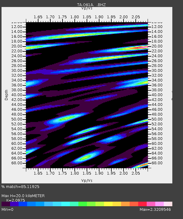
| Estimated Moho Depth: |
20.0 km |
| Estimated Crust Vp/Vs: |
2.10 |
| Assumed Crust Vp: |
6.283 km/s |
| Estimated Crust Vs: |
2.996 km/s |
| Estimated Crust Poisson's Ratio: |
0.35 |
|
| Radial Match: |
85.11925 % |
| Radial Bump: |
400 |
| Transverse Match: |
70.58657 % |
| Transverse Bump: |
400 |
| SOD ConfigId: |
796777 |
| Insert Time: |
2014-10-09 18:31:14.678 +0000 |
| GWidth: |
2.5 |
| Max Bumps: |
400 |
| Tol: |
0.001 |
|

Signal To Noise
| Channel | StoN | STA | LTA |
| TA:O61A: :BHZ:20140925T17:59:28.799988Z | 4.022269 | 1.7566684E-6 | 4.3673572E-7 |
| TA:O61A: :BHN:20140925T17:59:28.799988Z | 3.5809612 | 2.3460855E-6 | 6.5515525E-7 |
| TA:O61A: :BHE:20140925T17:59:28.799988Z | 1.8907882 | 1.7236194E-6 | 9.115878E-7 |
| Arrivals |
| Ps | 3.7 SECOND |
| PpPs | 9.4 SECOND |
| PsPs/PpSs | 13 SECOND |


