You are here: Home > Network List > TA - USArray Transportable Network (new EarthScope stations) Stations List
> Station P49A Miami Univ. Ecology Research Center, OH, USA > Earthquake Result Viewer
P49A Miami Univ. Ecology Research Center, OH, USA - Earthquake Result Viewer
| Earthquake location: |
Southern Alaska |
| Earthquake latitude/longitude: |
62.0/-151.8 |
| Earthquake time(UTC): |
2014/09/25 (268) 17:51:17 GMT |
| Earthquake Depth: |
103 km |
| Earthquake Magnitude: |
6.2 ML, 6.1 MI, 6.2 MWW, 6.3 MWR, 6.3 MWB, 6.3 MWC |
| Earthquake Catalog/Contributor: |
NEIC PDE/NEIC COMCAT |
|
| Network: |
TA USArray Transportable Network (new EarthScope stations) |
| Station: |
P49A Miami Univ. Ecology Research Center, OH, USA |
| Lat/Lon: |
39.53 N/84.72 W |
| Elevation: |
272 m |
|
| Distance: |
45.5 deg |
| Az: |
87.256 deg |
| Baz: |
322.375 deg |
| Ray Param: |
0.07089752 |
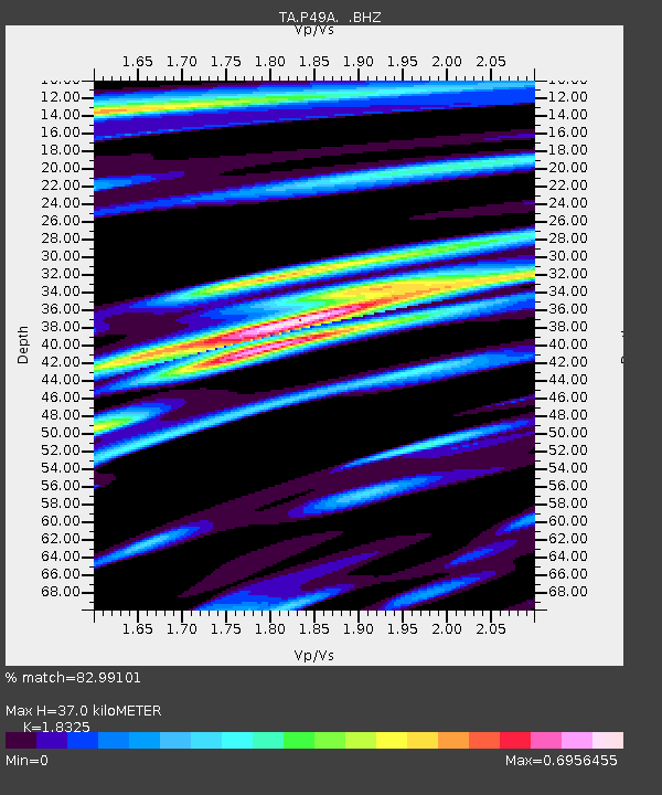
| Estimated Moho Depth: |
37.0 km |
| Estimated Crust Vp/Vs: |
1.83 |
| Assumed Crust Vp: |
6.498 km/s |
| Estimated Crust Vs: |
3.546 km/s |
| Estimated Crust Poisson's Ratio: |
0.29 |
|
| Radial Match: |
82.99101 % |
| Radial Bump: |
366 |
| Transverse Match: |
71.915726 % |
| Transverse Bump: |
400 |
| SOD ConfigId: |
796777 |
| Insert Time: |
2014-10-09 18:31:17.208 +0000 |
| GWidth: |
2.5 |
| Max Bumps: |
400 |
| Tol: |
0.001 |
|

Signal To Noise
| Channel | StoN | STA | LTA |
| TA:P49A: :BHZ:20140925T17:58:55.500Z | 3.4026892 | 7.4763386E-7 | 2.1971853E-7 |
| TA:P49A: :BHN:20140925T17:58:55.500Z | 1.973283 | 3.7482016E-7 | 1.8994749E-7 |
| TA:P49A: :BHE:20140925T17:58:55.500Z | 1.4015869 | 2.8838198E-7 | 2.057539E-7 |
| Arrivals |
| Ps | 5.0 SECOND |
| PpPs | 15 SECOND |
| PsPs/PpSs | 20 SECOND |


