You are here: Home > Network List > IU - Global Seismograph Network (GSN - IRIS/USGS) Stations List
> Station DAV Davao, Philippines > Earthquake Result Viewer
DAV Davao, Philippines - Earthquake Result Viewer

| Earthquake location: |
Northeastern India |
| Earthquake latitude/longitude: |
26.9/91.7 |
| Earthquake time(UTC): |
2006/02/23 (054) 20:04:53 GMT |
| Earthquake Depth: |
10 km |
| Earthquake Magnitude: |
5.5 MB, 5.3 MS, 5.8 MW, 5.5 MW |
| Earthquake Catalog/Contributor: |
WHDF/NEIC |
|
| Network: |
IU Global Seismograph Network (GSN - IRIS/USGS) |
| Station: |
DAV Davao, Philippines |
| Lat/Lon: |
7.07 N/125.58 E |
| Elevation: |
145 m |
|
| Distance: |
37.7 deg |
| Az: |
115.327 deg |
| Baz: |
305.59 deg |
| Ray Param: |
0.075969 |
| Estimated Moho Depth: |
47.5 km |
| Estimated Crust Vp/Vs: |
1.60 |
| Assumed Crust Vp: |
6.468 km/s |
| Estimated Crust Vs: |
4.042 km/s |
| Estimated Crust Poisson's Ratio: |
0.18 |
|
| Radial Match: |
99.90779 % |
| Radial Bump: |
19 |
| Transverse Match: |
99.30524 % |
| Transverse Bump: |
80 |
| SOD ConfigId: |
2669 |
| Insert Time: |
2010-03-02 01:56:19.411 +0000 |
| GWidth: |
2.5 |
| Max Bumps: |
400 |
| Tol: |
0.001 |
|
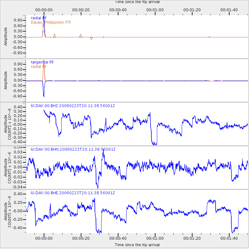
Signal To Noise
| Channel | StoN | STA | LTA |
| IU:DAV:00:BHN:20060223T20:11:38.56001Z | 1.7350504 | 1.683922E-8 | 9.70532E-9 |
| IU:DAV:00:BHE:20060223T20:11:38.56001Z | 1.6465822 | 2.460185E-7 | 1.4941159E-7 |
| IU:DAV:00:BHZ:20060223T20:11:38.56001Z | 1.6794697 | 2.2813857E-7 | 1.3583966E-7 |
| Arrivals |
| Ps | 4.8 SECOND |
| PpPs | 18 SECOND |
| PsPs/PpSs | 22 SECOND |


