You are here: Home > Network List > GS - US Geological Survey Networks Stations List
> Station KAN13 Rinehart Farm > Earthquake Result Viewer
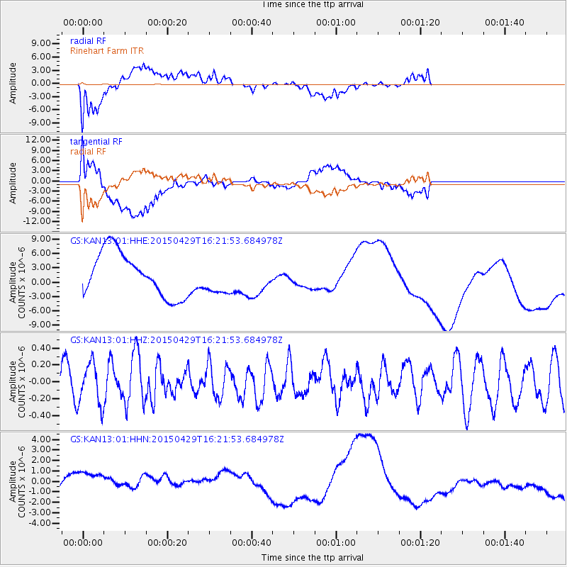
KAN13 Rinehart Farm - Earthquake Result Viewer
*The percent match for this event was below the threshold and hence no stack was calculated.
| Earthquake location: |
Near East Coast Of Honshu, Japan |
| Earthquake latitude/longitude: |
40.1/142.9 |
| Earthquake time(UTC): |
2015/04/29 (119) 16:09:51 GMT |
| Earthquake Depth: |
34 km |
| Earthquake Magnitude: |
5.4 MW, 5.3 mb, 5.3 MS |
| Earthquake Catalog/Contributor: |
ISC/ISC |
|
| Network: |
GS US Geological Survey Networks |
| Station: |
KAN13 Rinehart Farm |
| Lat/Lon: |
37.01 N/97.48 W |
| Elevation: |
340 m |
|
| Distance: |
85.4 deg |
| Az: |
44.267 deg |
| Baz: |
317.998 deg |
| Ray Param: |
$rayparam |
*The percent match for this event was below the threshold and hence was not used in the summary stack. |
|
| Radial Match: |
42.182343 % |
| Radial Bump: |
400 |
| Transverse Match: |
64.06679 % |
| Transverse Bump: |
400 |
| SOD ConfigId: |
7422571 |
| Insert Time: |
2019-04-18 14:23:54.622 +0000 |
| GWidth: |
2.5 |
| Max Bumps: |
400 |
| Tol: |
0.001 |
|
Signal To Noise
| Channel | StoN | STA | LTA |
| GS:KAN13:01:HHZ:20150429T16:21:53.684978Z | 1.2307118 | 2.449994E-7 | 1.990713E-7 |
| GS:KAN13:01:HHN:20150429T16:21:53.684978Z | 3.0663242 | 2.0376763E-6 | 6.645339E-7 |
| GS:KAN13:01:HHE:20150429T16:21:53.684978Z | 0.7806989 | 3.5820246E-6 | 4.5882284E-6 |
| Arrivals |
| Ps | |
| PpPs | |
| PsPs/PpSs | |


