You are here: Home > Network List > TA - USArray Transportable Network (new EarthScope stations) Stations List
> Station R56A Bull Pasture Mountain, McDowell, VA, USA > Earthquake Result Viewer
R56A Bull Pasture Mountain, McDowell, VA, USA - Earthquake Result Viewer
| Earthquake location: |
Southern Alaska |
| Earthquake latitude/longitude: |
62.0/-151.8 |
| Earthquake time(UTC): |
2014/09/25 (268) 17:51:17 GMT |
| Earthquake Depth: |
103 km |
| Earthquake Magnitude: |
6.2 ML, 6.1 MI, 6.2 MWW, 6.3 MWR, 6.3 MWB, 6.3 MWC |
| Earthquake Catalog/Contributor: |
NEIC PDE/NEIC COMCAT |
|
| Network: |
TA USArray Transportable Network (new EarthScope stations) |
| Station: |
R56A Bull Pasture Mountain, McDowell, VA, USA |
| Lat/Lon: |
38.41 N/79.40 W |
| Elevation: |
902 m |
|
| Distance: |
48.9 deg |
| Az: |
83.684 deg |
| Baz: |
323.275 deg |
| Ray Param: |
0.068721175 |
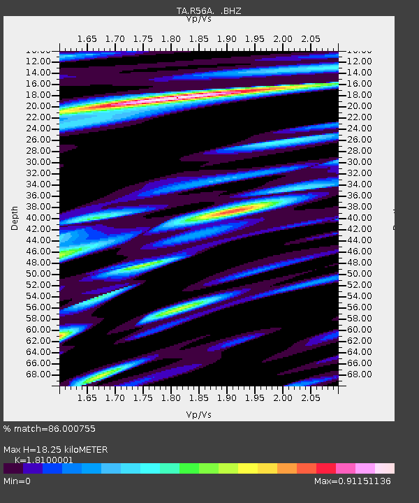
| Estimated Moho Depth: |
18.25 km |
| Estimated Crust Vp/Vs: |
1.81 |
| Assumed Crust Vp: |
6.159 km/s |
| Estimated Crust Vs: |
3.403 km/s |
| Estimated Crust Poisson's Ratio: |
0.28 |
|
| Radial Match: |
86.000755 % |
| Radial Bump: |
397 |
| Transverse Match: |
59.49802 % |
| Transverse Bump: |
400 |
| SOD ConfigId: |
796777 |
| Insert Time: |
2014-10-09 18:32:16.797 +0000 |
| GWidth: |
2.5 |
| Max Bumps: |
400 |
| Tol: |
0.001 |
|

Signal To Noise
| Channel | StoN | STA | LTA |
| TA:R56A: :BHZ:20140925T17:59:21.825012Z | 4.601881 | 8.1520966E-7 | 1.7714706E-7 |
| TA:R56A: :BHN:20140925T17:59:21.825012Z | 1.5239862 | 3.124944E-7 | 2.0505068E-7 |
| TA:R56A: :BHE:20140925T17:59:21.825012Z | 2.320659 | 3.4305472E-7 | 1.4782643E-7 |
| Arrivals |
| Ps | 2.5 SECOND |
| PpPs | 7.9 SECOND |
| PsPs/PpSs | 10 SECOND |


