You are here: Home > Network List > IW - Intermountain West Stations List
> Station MOOW Moose Ponds, Wyoming, USA > Earthquake Result Viewer
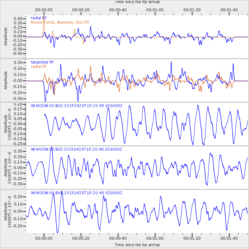
MOOW Moose Ponds, Wyoming, USA - Earthquake Result Viewer
*The percent match for this event was below the threshold and hence no stack was calculated.
| Earthquake location: |
Near East Coast Of Honshu, Japan |
| Earthquake latitude/longitude: |
40.1/142.9 |
| Earthquake time(UTC): |
2015/04/29 (119) 16:09:51 GMT |
| Earthquake Depth: |
34 km |
| Earthquake Magnitude: |
5.4 MW, 5.3 mb, 5.3 MS |
| Earthquake Catalog/Contributor: |
ISC/ISC |
|
| Network: |
IW Intermountain West |
| Station: |
MOOW Moose Ponds, Wyoming, USA |
| Lat/Lon: |
43.75 N/110.74 W |
| Elevation: |
2128 m |
|
| Distance: |
73.4 deg |
| Az: |
46.505 deg |
| Baz: |
309.812 deg |
| Ray Param: |
$rayparam |
*The percent match for this event was below the threshold and hence was not used in the summary stack. |
|
| Radial Match: |
58.569668 % |
| Radial Bump: |
400 |
| Transverse Match: |
67.629074 % |
| Transverse Bump: |
400 |
| SOD ConfigId: |
7422571 |
| Insert Time: |
2019-04-18 14:24:17.783 +0000 |
| GWidth: |
2.5 |
| Max Bumps: |
400 |
| Tol: |
0.001 |
|
Signal To Noise
| Channel | StoN | STA | LTA |
| IW:MOOW:00:BHZ:20150429T16:20:48.939006Z | 2.0824516 | 2.1591929E-7 | 1.0368514E-7 |
| IW:MOOW:00:BH1:20150429T16:20:48.939006Z | 0.78016025 | 8.4056325E-8 | 1.0774239E-7 |
| IW:MOOW:00:BH2:20150429T16:20:48.939006Z | 2.029795 | 1.1025731E-7 | 5.431943E-8 |
| Arrivals |
| Ps | |
| PpPs | |
| PsPs/PpSs | |


